Nov
16
2008
 Lavender Canyon (Moab, UT)
Lavender Canyon is an easy trail that follows the sandy bottom of Lavender Canyon and heads into Canyonlands National Park. When the trail reaches the National Park boundary there is a locked gate. In order to proceed to the last few miles of the trail within the park, you need to get a day permit and the combination to the lock from the ranger station. When we ran the trail the day permit cost $5.
There are a number of arches located in Lavender Canyon and even a few Indian ruins. The two bigger arches include Cleft Arch near the end of the trail and Caterpillar Arch near the park boundary. The nearby Dry Fork Canyon just outside the park boundary also has an arch or two to check out. This trail is about 15 miles to the park boundary from UT 211 and a few more miles after that point. There is also another route that heads up West Fork Canyon in the park that can be explored. Outside of the park, there is also Dry Fork Canyon and Davis Canyon to check out. If you want to check out this trail with all of the other nearby canyons, plan on spending a very long day or camp overnight outside of Canyonlands.
It appears that Lavender Canyon is not as popular as some of the other trails in the Needles District of Canyonlands, however it is certainly worth checking out if you enjoy searching for arches and Indian ruins.
Please feel free to leave your comments and post your pictures from Lavender Canyon below.
 Lavender Canyon KML Track
(Right click and ‘Save Target As’)
Open file above in Google Earth.
Comments Off on Lavender Canyon | posted in Trails
Nov
10
2008
 Elephant Hill (Moab, UT)
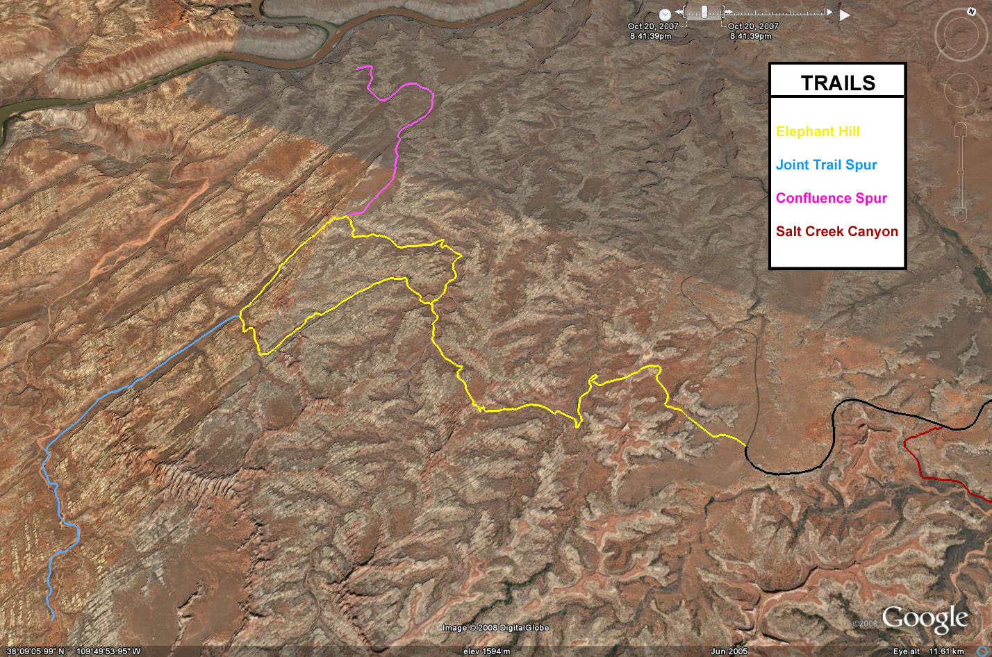
Elephant Hill is an awesome trail located in the Needles district of Canyonlands National Park. Much of the trail is easy, but in order to reach the easier section you need to get over the more difficult Elephant Hill right at the beginning. This section of the trail is steep and narrow with a few very tight switchbacks. Stock 4×4 vehicles with an experienced driver should have no problems with Elephant Hill. This is a loop trail with two main spurs. The loop section is one-way and is run in the clockwise direction.
The Devil’s Pocket is a narrow section, just wide enough for a Jeep to fit through that makes for a great photo stop. The first main spur trail heads down the Devil’s Lane and over S.O.B. Hill and takes you to the Joint Trail. The Joint Trail is a very cool hiking trail that leads you through a narrow slot canyon to Chesler Park and is just over a mile in length. Both the slot canyon and Chesler Park offer some excellent views and photo opportunities.
After leaving The Joint Trail you will head back up Devil’s Lane and over the Silver Stairs and can make your way to The Confluence Overlook spur trail. This spur dead ends at a short hiking trail that leads you to the Confluence Overlook of the Colorado and Green Rivers. From here you complete the loop and head back over Elephant Hill and out the way you came.
This is a very scenic trail and a long way from Moab. Make sure your gas tank is full and be prepared to spend a long day on the trail if you plan to complete the optional hikes and spur trails. If you are looking for camping nearby, there are a few campsites in Canyonlands, but you may want to reserve your site in advance to make sure there is one available.
Please feel free to leave your comments and post your pictures from Elephant Hill below.
Elephant Hill KML Track
(Right click and ‘Save Target As’)
Open file above in Google Earth.
Comments Off on Elephant Hill | posted in Trails
Nov
7
2008
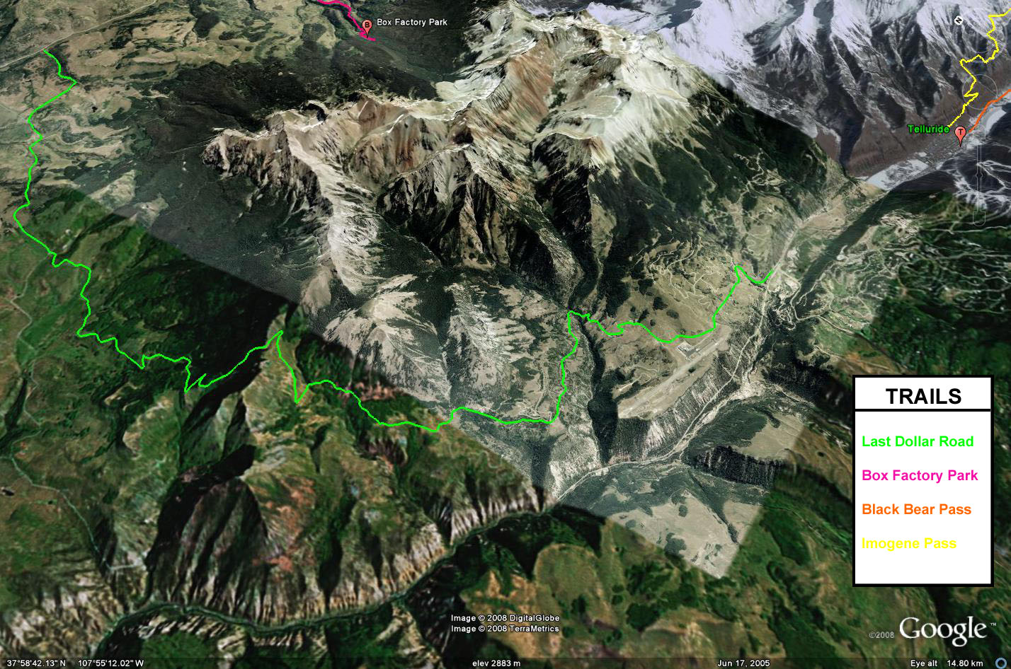
 Last Dollar Road (Telluride, CO)
Last Dollar Road is an easy but very scenic drive that takes off from Colorado Highway 62 and finishes off near Telluride. This was an early supply route between Ridgway and Telluride. The road starts out about a mile west of the Dallas Divide and travels over Hastings Mesa which is covered with ranchland. There are great views of the Sneffels Range to the east as you travel this section of road. After crossing the ranchland, the road gets a bit narrower and makes it’s way through some forested areas and some talus slopes before reaching the Telluride Airport.
In the spring, this trail offers abundant wildflowers. In the fall, this trail offers spectacular colors to photograph and enjoy. I highly recommend checking out this trail in the fall when the aspens are changing color. Any high clearance vehicle should have no troubles with this trail, but there are a few small creek crossings that may give passenger vehicles some trouble.
Please feel free to leave your comments and post your pictures from Last Dollar Road below.
Last Dollar Road KML Track
(Right click and ‘Save Target As’)
Open file above in Google Earth.
Comments Off on Last Dollar Road | posted in Trails
Nov
6
2008
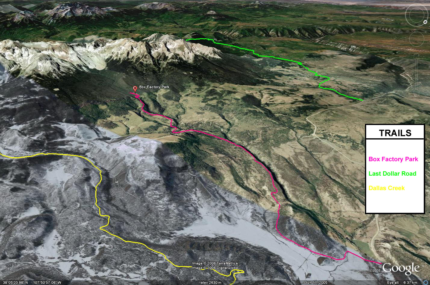
 Box Factory Park (Ridgway, CO)
Box Factory Park, also known as West Dallas Creek is a short spur trail that takes off from Colorado Highway 62 a few miles west from Ridgway. The trail starts out by travelling through the private Double RL Ranch ranch, which is owned by Ralph Lauren. The road through this ranch is in good shape and is suitable for any vehicle. Once past the private property, the road does get a bit rougher, but it’s nothing a stock high clearance vehicle can’t handle.
Along the trail past the ranch, there is a deep canyon that was formed by the North Fork of Dallas Creek. In places it is only a few yards from the road, but is difficult to see unless you get out of your vehicle and look through the brush. As you make your way towards the base of Mount Sneffels the road will enter a dense forest and will turn into a rutted two-track. There is a small creek crossing shortly before entering the large open area known as Box Factory Park.
This open area offers spectacular views of Mears Peak in front of you and is a great place for photographs. This area offers even better views in the fall when the Aspens are changing colors. I highly recommend this trail for a Fall Colors trip.
Please feel free to leave your comments and post your pictures from Box Factory Park below.
Box Factory Park KML Track
(Right click and ‘Save Target As’)
Open file above in Google Earth.
Comments Off on Box Factory Park | posted in Trails
Nov
5
2008
 Golden Spike (Moab, UT)
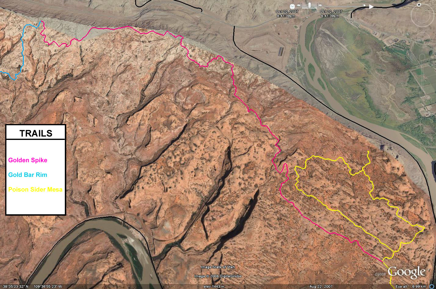
Golden Spike is a difficult and bumpy trail that takes a while to complete, even though it is only seven miles in length. There are a number of challenges and famous obstacles along this trail. Some of them such as double whammy, are optional, but a majority of them do not have a bypass. Launch Pad, Skyline Drive, the Golden Stairs and the Golden Crack are some of the more notable obstacles on this trail.
In order to reach Golden Spike, you must approach it from either the Poison Spider Mesa trail or by Gold Bar Rim and Rusty Nail. Most commonly, this trail is run starting from Poison Spider Mesa and finishing on Gold Bar Rim. This is an excellent route to tackle this trail, but be warned, it will take a good majority of the day to complete this trail, so make sure you are prepared. Many groups have been stuck on this trail overnight because of broken parts on the trail. I ran this trail with two other Jeeps and it took us almost seven hours to complete.
This is definitely a ‘must do’ trail in the Moab area, but it is certainly not for stock vehicles. A modified 4×4 vehicle is recommended with a driver who has experience.
Please feel free to leave your comments and post your pictures from Golden Spike below.
Golden Spike KML Track
(Right click and ‘Save Target As’)
Open file above in Google Earth.
Comments Off on Golden Spike | posted in Trails