Dec
7
2012
Veterans Day | Monday, November 12, 2012
After spending a great weekend exploring The Paria Plateau it was time to start our drive back home. Before we left I thought it might be a good idea to finally check out Upper Antelope Canyon. I’ve seen plenty of photos from this well-known location but have always avoided it because of the large crowds of people that visit. I was hoping that since this was the “off season” it wouldn’t be too busy. Was I wrong! There were quite a few different groups of people in there. I was expecting there to be other people in the slot canyon, so I had prepared myself for it and wasn’t too bothered by it. I just planned to take most of my photos looking up out of the slot where other people wouldn’t get in the shot. However, what really frustrated the hell out of me was that many of these people were taking pictures with their point and shoot cameras that used a red focus-assist light that ruined most of my shots. Upper Antelope Canyon may be one of the most beautiful slot canyons in the world, but I highly doubt that I will ever be returning. It’s just not worth it to me.
Here’s a few of the photos I was able to get while I was in the slot canyon.
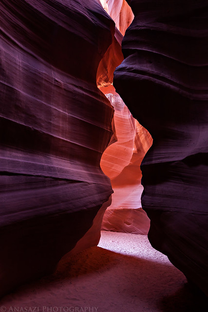
Enter by IntrepidXJ, on Flickr
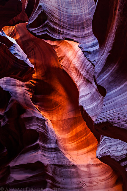
Light Stripe by IntrepidXJ, on Flickr
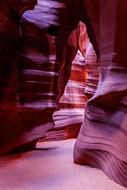
Upper Antelope by IntrepidXJ, on Flickr
2 comments | posted in Adventures, Anasazi, Arches, Canyoneering, Hiking, Photography, Rock Art, Trip Reports
Nov
26
2012
Thursday – Sunday, November 1-4, 2012
After work on Thursday evening I got in my Jeep and drove into Utah again. I had taken Friday off from work and was planning on meeting a group of friends in Beef Basin for a long weekend of camping and exploring the area. A few months earlier my friend Rob had tipped me off about a large petroglyph panel in the area he knew I would be interested in finding, and that was the beginning of planning for this trip. I arrived at our predetermined campsite in the dark and found Marty already there with his tent setup and a campfire already going. I was surprised to only be the second person there but knew the others would arrive shortly. Twenty minutes later Alex, Rob and his companions showed up. We sat around the fire for a little while waiting for the others, but headed to bed before anyone else arrived since we planned an early start for the following day. As soon as we were in our sleeping bags Jared and his brother Brian showed up. Later that night I heard Dave and his son pull up in their Jeep. We had all made it.
Friday morning I was up early and it looked like there might be a good sunrise, so I got in my Jeep to find a place to take some photos and ended up at a nearby ruin. I was hoping the sky would light up with color, but only the horizon turned a little pink.
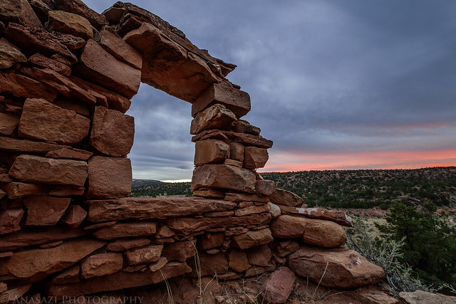
Open Window by IntrepidXJ, on Flickr
After returning to camp and waiting for everyone else to finish getting ready we got in our vehicles and drove over to the Fable Valley Trailhead. We were planning on exploring Gypsum Canyon following a route that Rob had planned out.
We started out hiking along an old closed road that followed the rim of the canyon. This is looking back at the confluence of the two upper forks of Gypsum Canyon.
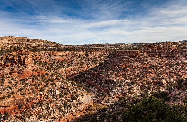
Gypsum Fork by IntrepidXJ, on Flickr
Once the old road ended we were left scrambling and route-finding our way along the rim of the canyon and then across a small side canyon.
Looking down the canyon towards the confluence with Fable Valley from the rock we stopped at for a lunch break.
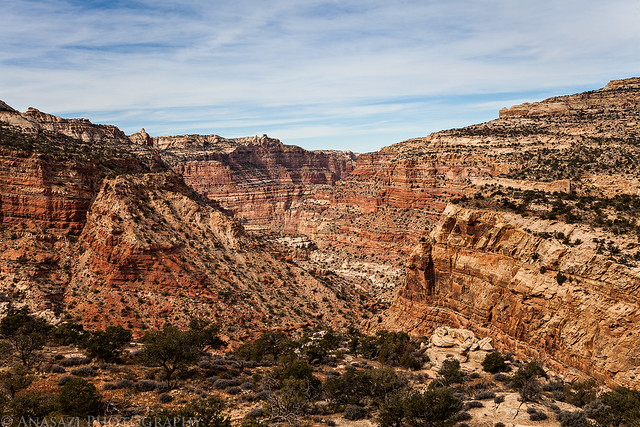
Down Canyon by IntrepidXJ, on Flickr
1 comment | posted in Adventures, Anasazi, Camping, Canyoneering, Hiking, Photography, Rock Art, Trip Reports
Nov
28
2010
Saturday, November 27, 2010
On Saturday, Amanda and I headed west to the San Rafael Swell so we could go for a hike in Wild Horse Canyon. Before reaching our destination, we stopped by the pictographs along Temple Mountain Wash.
We eventually made our way to Wild Horse Canyon. We hiked up the canyon in search of some more pictographs….which I found high up in an alcove.
Next we scrambled out of the canyon and found the Wild Horse Window (Skylight Arch)
Continue reading
Comments Off on Wild Horse Canyon | posted in Adventures, Arches, Canyoneering, Hiking, Rock Art, Trip Reports
Nov
22
2010
Friday & Saturday, November 19-20, 2010
This last weekend was our annual November trip to the Cedar Mesa / Comb Ridge area. We set out to check out some new ruins and rock art during the weekend and we were not disappointed. On Friday we both got out of work early and headed south to Blanding. On our way we made a quick stop at the Dewey petroglyph panel for a few quick photos before it got dark.
On our way towards Monticello I noticed a nice pink glow over the La Sal Mountains as the sun was setting, so I pulled over to take a quick picture.
Right after I took that photo, the pink glow disappeared.
After dinner in Monticello we finished the drive to Blanding, checked into our hotel (we’re not into cold weather camping) and got to sleep so we could get an early start the next morning.
We were up well before the sun was to rise on Saturday morning and on our way to Cedar Mesa. Our first destination for the day was Road Canyon, and we arrived at the trailhead just after the sun had come up. Here’s a few photos from our hike through Road Canyon…
Fallen Roof Ruin was high on my list of ruins to hike to, so that was our first stop
Fallen Roof
Amanda and I
We continued on down Road Canyon a little further to find a few more ruins.
These ruins had a real ‘fallen roof’
I climbed up to this well preserved granary
Continue reading
Comments Off on November Ruins & Rock Art | Friday & Saturday | posted in Adventures, Anasazi, Arches, Canyoneering, Hiking, Photography, Rock Art, Trip Reports
Nov
2
2010
Sunday, October 31, 2010 (Halloween)
On Sunday I was on my own again and didn’t want to get too far from home. I decided to head over into Utah to do some more exploring around the Yellow Cat and Highlands areas just north of Arches National Park. I started out by checking out a few trails around Lost Spring Canyon before making my way over to Winter Camp Ridge. In the spring I had started to look for a short slot canyon in the area, but didn’t have the time to complete the search. This time I knew exactly where I was going and took the short hike down into the Winter Camp slot canyon.
Different color on each wall of the slot
After finishing up the hike I had a quick lunch and then headed north towards the Book Cliffs.
View across Sagers Flat with the La Sal Mountains in the background
It seems that I end up visiting the Sego Canyon pictographs and petroglyphs about once a year, so I figured I would keep up the tradition…
Some Barrier style pictographs
Continue reading
Comments Off on Winter Camp Slot, Sego Canyon & More | posted in Adventures, Barrier Canyon Style, Canyoneering, Fremont, Rock Art, Trip Reports, Ute


