Dec 26 2012

After Thanksgiving Swell Trip

San Rafael Swell Rock Art X
Black Friday & Saturday, November 23-24, 2012

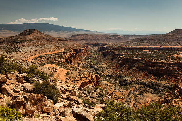
After spending most of Thanksgiving Day at home it was time to get back out exploring again. Normally I take at least a few trips throughout the year to the San Rafael Swell, but I guess I was too preoccupied with the Paria Plateau this year since I still hadn’t made it out there. I decided it was time to at least make one trip out to the Swell this year, so that’s where I headed. I left well before sunrise on on Black Friday and was still surprised to see so many cars park at the mall that early as I drove out of town. I still can’t imagine getting up that early to try and get a deal among a large crowd of people, I’d rather spend my morning catching a sunrise in the desert. I spent the daylight hours of Friday and Saturday exploring, hiking and photographing rock art sites. I revisited a few sites and searched for some new ones. I spent the night at a hotel in Green River so I didn’t have to drive all the way back home on Friday night. Though many of the sites I visited were in the San Rafael Swell, I also made a side trip or two into the Book Cliffs and other areas outside the Swell. Here’s a few photos from my two days of exploring…

One of the new sites I visited this trip was the petroglyph panel near Mussentuchit Flats. When I first arrived, most of the panel was in direct sunlight, except for this narrow section, which happened to be one of the more interesting parts. As soon as the sunlight struck this section, it was almost impossible to see these figures.


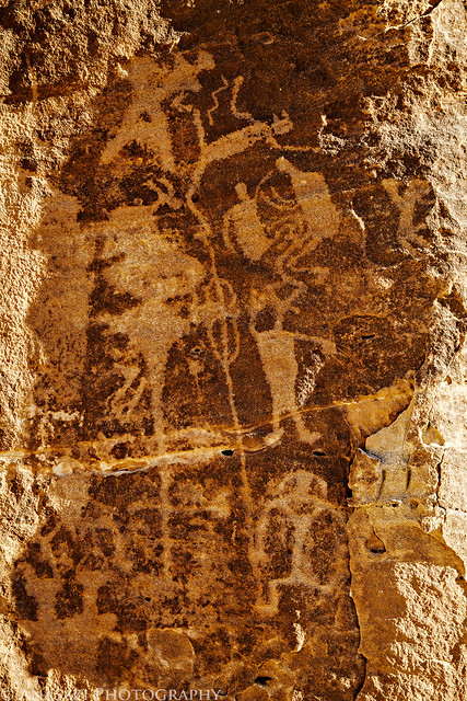
Mussentuchit by IntrepidXJ, on Flickr

The fading Butch ‘Casady’ inscription under a shallow overhang.


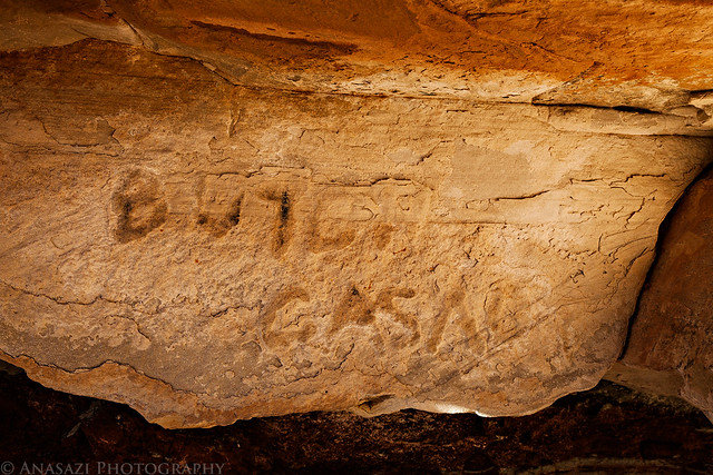
Butch Casady by IntrepidXJ, on Flickr

Cracked mud in the early morning light.


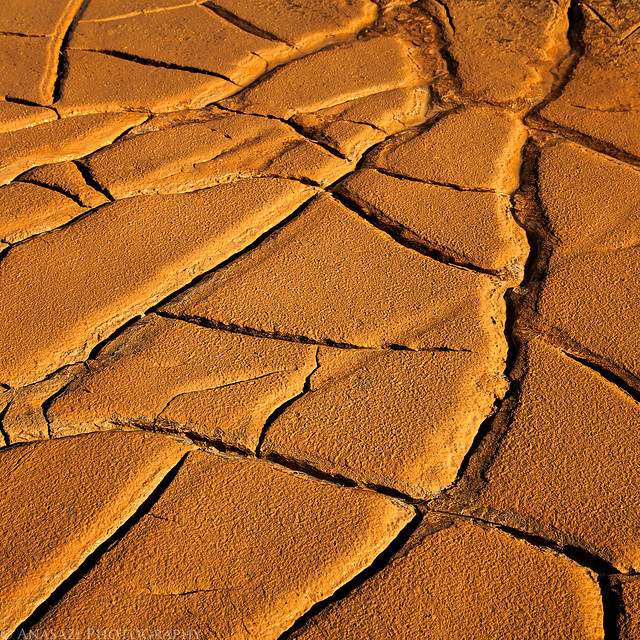
Cracks by IntrepidXJ, on Flickr

I’ve searched for this Barrier Canyon Style figure before without success, so I was happy to come across it this time.


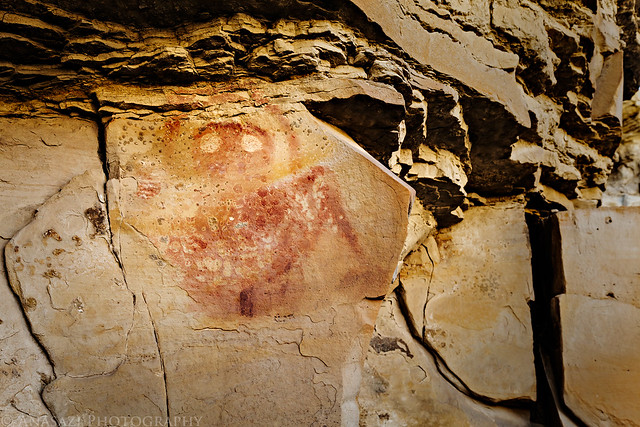
Top Half by IntrepidXJ, on Flickr


Aug 26 2012

Taylor Lake to Hancock Lake

Friday – Sunday, August 17-19, 2012

I went to work on Friday with all my camping gear loaded in my Jeep, but no plans on where to go. I just knew I wanted to get up in the mountains for two nights, but not to the San Juan’s again. When I finally left work, I decided to make my way towards Aspen since I haven’t been that way for a while. As I was driving to Aspen I tried to think of any lakes that I could camp by to hopefully catch a good sunrise, and the only one I could think of was Taylor Lake, so that’s where I headed.

As I was driving up to Taylor Pass on the Express Creek Road, the late evening sunlight was filtered through a thick layer of smoke that has blanketed most of Colorado all week causing it to appear much warmer than normal.


Yellow Road by IntrepidXJ, on Flickr

Driving up the final switchback to reach Taylor Pass.


To Taylor Pass by IntrepidXJ, on Flickr

The sun getting close to setting behind the Elk Mountains. The sky still filled with smoke.


Smoky Sun by IntrepidXJ, on Flickr


May 23 2012

Lost Canyon & Squaw Canyon Loop

Saturday, May 5, 2012

On Saturday morning I set out early to drive down to The Needles District of Canyonlands National Park. One of my goals for 2012 was to spend more time hiking and exploring in this amazing area. Unfortunately, because of circumstances earlier this year I was unable to make it down here until now, so I’m getting a later start than I had originally planned. Better late than never, I guess. I’ve still got plenty of time this year to return a few more times 😉

When I made it to the park I headed straight for the Squaw Flat Campground and started hiking the Lost Canyon and Squaw Canyon loop trail. It was a beautiful morning that was perfect for hiking. I made it to Lost Canyon in no time.

The well-used trail to Squaw Canyon, Lost Canyon and eventually Peekaboo.


Trail Ahead by IntrepidXJ, on Flickr

Crossing the sandstone of the Squaw – Lost Canyon Divide


Lost Canyon Divide by IntrepidXJ, on Flickr

Following the cairns.


Lost Canyon Trail by IntrepidXJ, on Flickr


May 16 2012

Backpacking Big Dominguez Canyon

Saturday & Sunday, April 28-29, 2012

I’m proud to say that I have finally gone on my very first backpacking trip. I’ve been collecting gear for the past few months and finally scheduled a trip with my friend Jackson and his dad. Since this was my first time, I wanted to keep the trip shorter and closer to home…kind of like a trial run to see how it all went. I’m happy to report that everything went well, and I’m looking forward to my next backpacking trip in the future.

Overall, I think I made some good choices when I was selecting gear over the past few months, but I’m sure I’ll be making some changes here and there to try and get the weight down further. With my pack loaded up with camping gear, food, water and camera gear, I was carrying just under 40lbs (with my camera around my neck, the weight on my back dropped to 35lbs). I’d like to get that number closer to 30lbs in the future, but it’s probably going to take some trial and error.

Since I was looking for a destination close to home and with not too long of a hike, we settled on Big Dominguez Canyon. It’s only about 20 miles from my house and was supposed to be about 7 miles in length. I have day-hiked the canyon from Bridgeport a few times before, but never gone more than a few miles in. This time we would be starting from the Cactus Park trailhead and descending down the canyon to Bridgeport.

After dropping off a truck at Bridgeport on Saturday morning, we loaded up my Jeep and drove up to Cactus Park. We were expecting to be able to drive to the rim of Dominguez Canyon and then hike down into the canyon, but that’s not quite how it worked out. What we found was a pretty new gate across the road about two miles from the canyon. Apparently, when this area became an official wilderness back in 2009, they must have extended the boundaries or removed the cherry-stem for this road and closed it. So, right from the start our planned hike was going to be two miles longer. We got our packs on our backs and started hiking down the closed road.

An old sign indicating the way to Dominguez Canyon found along the old closed road. The Wilderness Study Area sign is a bit outdated since this area is officially a Wilderness now.


Dominguez Canyon Trail by IntrepidXJ, on Flickr

Jackson and his dad are birders, so they frequently stopped to find and identify birds they heard along the way.


Bird Watching by IntrepidXJ, on Flickr

When we finally reached the rim, we had a difficult time locating the trail down into the canyon. We ended up walking the rim looking for a way down the wrong way at first and then had to retrace our path and hike the other way. We did finally manage to find the steep route into the canyon, but it ended up adding a few more miles to our hike.

A great view from the rim of the canyon with Triangle Mesa and the Grand Mesa in the distance.


Big Dominguez Canyon & Triangle Mesa by IntrepidXJ, on Flickr

Jackson’s dad on the rim of the canyon as we tried to figure out the way down.


On the Edge by IntrepidXJ, on Flickr


Apr 25 2012

Sunrise in Bryce and the Drive Home

Las Vegas Trip 2012
Saturday, March 17, 2012

It was the last day of our trip to Las Vegas and Southern Utah and we would finally be heading back home. Of course we would be making some more stops on the way back! After another night in another hotel we were up early again to catch one more sunrise. I was looking forward to photographing Bryce Canyon at sunrise and was hoping for a good one as we drove into the park in the dark.

While exploring the park the previous evening I had decided that I wanted to photograph sunrise from Sunset Point, so that’s where we headed. We were the first car in the parking lot that morning as I walked out to the overlook and setup my camera. When I first saw the sky turn bright pink out over Navajo Mountain, I had a feeling this was going to be a good sunrise! This photo was taken just before the sun came up over the horizon.


Bryce Canyon Sunrise by IntrepidXJ, on Flickr

Once the sun rose above the horizon, it bathed the spires in a nice golden light.


Bryce Rim Sunrise by IntrepidXJ, on Flickr

The view towards Inspiration Point.


Inspiration Point by IntrepidXJ, on Flickr

I’m not sure if this is normal here at Bryce, but all of a sudden the light changed and everything was glowing a very bright and vibrant reddish-orange. I have never seen anything like it before. I managed to quickly take two or three photos but the neon color quickly disappeared almost as quickly as it had appeared. The colors were really this vibrant!


Bryce Sunrise Colors by IntrepidXJ, on Flickr