Mar 7 2013

Zabriskie Point to Badwater

Death Valley Trip 2013 | Day 3
Monday, February 11, 2013

The Original Trip Report on ADVENTR.CO

My alarm woke me up a few hours before sunrise on Monday morning. I quickly got my camp loaded back in the Jeep and started the short drive over to the popular Zabriskie Point. As usual, I was the first to arrive with plenty of time to scout the location in the dark. I guess I should mention that it was my birthday. I had purposely planned this trip to coincide with my birthday, and I couldn’t think of a better way to spend the day.

Looking over the badlands from Zabriskie Point shortly before the sun would rise for the day.


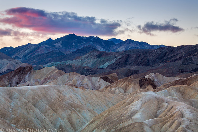
Zabriskie Badlands by IntrepidXJ, on Flickr

The prominent Manly Beacon, the Panamint Range and the Earth’s shadow come together for this scene.


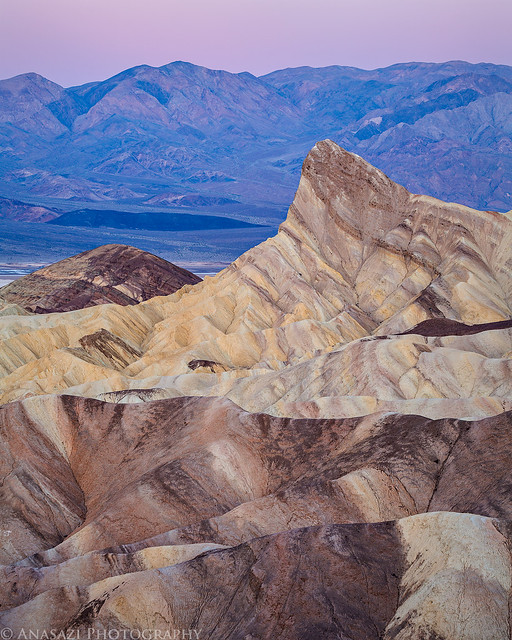
Manly Dawn by IntrepidXJ, on Flickr

First light on the Panamint Range on the other side of Death Valley.


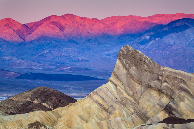
Zabriskie Point Morning by IntrepidXJ, on Flickr

There were even a few clouds if you looked further south. I love the light on the Panamints in this image.


Morning Light by IntrepidXJ, on Flickr

A closer look at Manly Beacon while the Panamint Range in the distance is lit up by the early morning sunlight.


Manly Beacon by IntrepidXJ, on Flickr

One last view of Manly Beacon right after it is struck by direct sunlight.


Zabriskie Point Sunrise by IntrepidXJ, on Flickr

I like the play of shadows and light in this view towards the Red Cathedral.


Red Cathedral Shadows by IntrepidXJ, on Flickr

When the sun was high enough in the sky I packed up my gear and drove the short distance to Furnace Creek. Since it was my birthday, I decided to stop in at the 49′er Cafe for a good hearty breakfast. Before long, my plate was empty and I was back on the road. This time I was headed back into Nevada so I could drive the Titus Canyon Road back into the park. Since Beatty, Nevada was only a few miles further, I continued into town to top off my gas tank. Gas was much cheaper in Beatty.

Following the well-maintained road through the Grapevine Mountains towards Titus Canyon.


Titus Canyon Road by IntrepidXJ, on Flickr

I stopped for a quick photo here because I liked the unusual striations in the layers of rock that make up the canyon wall.


Bent Rock by IntrepidXJ, on Flickr

After a nice drive through the mountains and canyon, I soon reached Klare Spring where there are a few petroglyphs to be found.


Titus Petroglyphs by IntrepidXJ, on Flickr

I’m guessing this represents a bighorn sheep.


Klare Spring Sheep by IntrepidXJ, on Flickr

Soon I entered the Titus Canyon Narrows. There were a few bends with nice light reflecting off the canyon walls.


Titus Canyon Narrows by IntrepidXJ, on Flickr

Another stop to capture the reflected light. Of course, after I rounded the next bend I started running into photographers standing in the middle of the road with their tripods setup…


In the Narrows by IntrepidXJ, on Flickr

After exiting the canyon I drove south through Furnace Creek again and then followed the West Side Road to Trail Canyon. I drove up this 4×4 road a little way and setup my camp for the evening. This is the closest to sea level that I have camped in a long time.


Trail Canyon Camp by IntrepidXJ, on Flickr

Once my camp was setup I drove over to Badwater so I could photograph the interesting salt polygons that make up the floor of the basin.


Badwater Shadow by IntrepidXJ, on Flickr

The last light of the day strikes the top of the mountains while the Badwater basin is in the shadows.


Badwater Sunset by IntrepidXJ, on Flickr

The shape and textures found in the salt are very unique. I spent a lot of time hiking around the area looking for different compositions. I thoroughly enjoyed the blue and magenta colors reflecting off the salt flat during twilight.


Badwater Twilight by IntrepidXJ, on Flickr

After hiking back to my Jeep I noticed the sliver of a crescent moon over the Panamint Range and thought it might make a nice simple image. I switched over to my long lens for this shot.


Crescent by IntrepidXJ, on Flickr

Since it was still my birthday I thought it would be nice to drive back to Furnace Creek and grab a burger at the 49′er Cafe. I ended up having to wait about 30 minutes to be seated, but they did have a pretty decent burger. After the meal, I drove back to my camp along the Trail Canyon Road and fell asleep very quickly after a long day exploring Death Valley.

>> Zabriskie Point to Badwater Photo Gallery


Mar 6 2013

Falling Man to Dante’s View

Death Valley Trip 2013 | Day 2
Sunday, February 10, 2013

The Original Trip Report on ADVENTR.CO

After a good night of sleep my alarm woke me up before the sun was expected to rise. When I got out of my tent I noticed that some thin clouds had moved in overnight and the sky was completely overcast. I had originally planned to spend some time photographing Little Finland this morning, but with the overcast skies I decided to cancel those plans. Instead, I had a little breakfast, packed up my camp and started driving towards my next destination- the Falling Man petroglyph site.

On my way to the Falling Man site I drove right by Devil’s Throat, so I stopped for a quick look. It’s a giant sinkhole in the desert floor. This is not a good photo, but I’m posting it up anyway since I bothered to stop here.


Devil’s Throat by IntrepidXJ, on Flickr

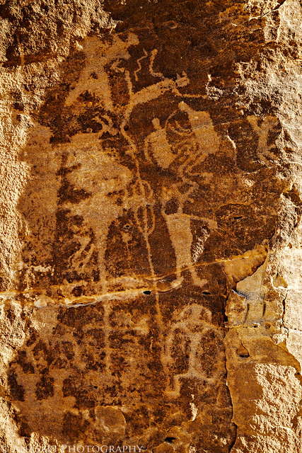
When I made my plans to spend the first weekend of my trip in the Gold Butte region I really thought that the Kohta Circus petroglyphs were going to be the highlight of my visit. I was wrong. I had a lot more fun exploring the area around the Falling Man petroglyph. Not only were there petroglyphs to be found everywhere I looked, there was also colorful sandstone all over the place. It was like walking through a colorful maze searching for rock art around every corner! I spent more time in this area than I had anticipated and look forward to returning again in the future.

A photo of colorful sandstone in a small alcove reminiscent of scenes found at the Valley of Fire.


Color by IntrepidXJ, on Flickr

To access the rock art I had to first crawl through this passage in the rock. The petroglyphs lead the way.


Petroglyph Passage by IntrepidXJ, on Flickr

Soon I found myself face to face with the interesting Falling Man petroglyph that I had come to see.


Falling Man by IntrepidXJ, on Flickr

This spot of color on the sandstone was found nearby.


Colorful Spot by IntrepidXJ, on Flickr

There were many smaller petroglyph panels to be found as I hiked around the area. This large boulder was the next larger site I came across.


Boulder Panel by IntrepidXJ, on Flickr

A closer look at part of the panel.


Boulder Panel Detail by IntrepidXJ, on Flickr

As I climbed around the maze some more I found myself on a ledge containing another nice set of petroglyphs.


Hash Marks by IntrepidXJ, on Flickr

A better look at the right side.


Upper Panel by IntrepidXJ, on Flickr

While standing on the ledge I noticed there was another large panel of petroglyphs right below my feet. There was no immediate way down to the next level, so I hiked around until I found a way down. When I reached the panel I was treated to another impressive group of petroglyphs.


Newspaper Panel by IntrepidXJ, on Flickr

Great colors in the sandstone found in this area. You might also notice that the overcast skies finally started to clear out a little as I explored the area.


Colorful Scene by IntrepidXJ, on Flickr

Petroglyphs and colorful sandstone, a wonderful combination.


Petroglyphs & Colors by IntrepidXJ, on Flickr

One of the many small panels found in the area.


Sheep by IntrepidXJ, on Flickr

Hiking back to my Jeep among the Joshua Trees.


Falling Man Trail by IntrepidXJ, on Flickr

Before heading back to the interstate, I made one last stop near Whitney Pocket so I could search for some more rock art. The petroglyphs I found here were faded and harder to see, but I liked this panel surrounded by bright green lichen.


Green Lichen by IntrepidXJ, on Flickr

From Whitney Pocket I drove back north until I reached the interstate. I headed west and grabbed some lunch on the outskirts of Las Vegas before finishing the drive to Death Valley National Park. Once in the park I drove up to Dante’s View which overlooks Badwater and a good portion of Death Valley. There were quite a few people at the viewpoint, so I hiked to the top of Dante’s Peak which I had all to myself.

Following the trail to Dante’s Peak over Badwater.


Dante’s Peak Trail by IntrepidXJ, on Flickr

There were some storms and clouds moving over Death Valley adding some drama to the landscape.


Death Valley Storm by IntrepidXJ, on Flickr

The surrounding mountains play hide and seek in the low clouds. I could sit and watch this dynamic scene all day.


Mountains & Clouds by IntrepidXJ, on Flickr


Between the Clouds by IntrepidXJ, on Flickr

After my hike to Dante’s Peak I decided to drive back down and find a campsite in Greenwater Valley before it got dark out.


Greenwater Camp by IntrepidXJ, on Flickr

Once my camp was setup I make a quick drive over to Zabriskie Point so I could scout out the location for the following morning’s sunrise. On my way I pulled over when these layers of desert colors caught my attention.


Layers by IntrepidXJ, on Flickr

The clouds and storms in the area create a momentary spotlight on this peak.


In the Light by IntrepidXJ, on Flickr

After checking out Zabriskie Point I drove back up to Dante’s View to catch the sunset.

When I arrived at the top there were a lot of clouds blocking the light, but the sun did manage to slip through a small hole to light up small sections of the valley floor.


Badwater Spotlight by IntrepidXJ, on Flickr

I thought this looked like a cool little cloud.


Cloud by IntrepidXJ, on Flickr

There were too many clouds for a great sunset, but shortly after the sun dipped below the Panamint Range these clouds did get a little color.


Purple Mountains by IntrepidXJ, on Flickr

I stayed at the viewpoint until I was the last one up there (this is usually the case). As I started my drive back down to camp it actually started snowing a little bit, but once I lost a little elevation I managed to get out of the snow. Once I was back in camp I had a little dinner, read for a little while and fell fast asleep so I would be ready for a new day.

>> Falling Man to Dante’s View Photo Gallery


Mar 5 2013

Kohta Circus & Little Finland

Death Valley Trip 2013 | Day 1
Saturday, February 9, 2013

The Original Trip Report on ADVENTR.CO

It’s been an unusually long and cold winter this year in Grand Junction. That’s why I’m glad I started planning my first trip to Death Valley a few months earlier. It would be nice to get out hiking and camping in temperatures that were a bit warmer than back at home. Though my main destination on this week-long trip would be Death Valley, I planned on spending the first weekend exploring a few locations in Nevada. On Saturday morning I left home bright and early and started my drive west.

As I approached Salina the sun started to come up and painted the clouds above a pink hue. I pulled over for a quick photo over the interstate.


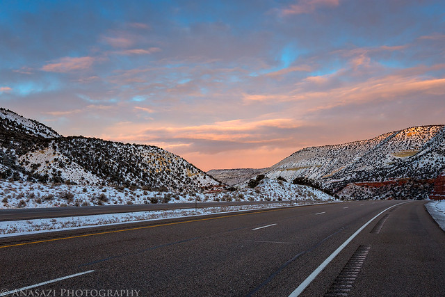
Salina Sunrise by IntrepidXJ, on Flickr

A layer of fresh snow that fell overnight coated the landscape and caught my attention.


Fresh Snow by IntrepidXJ, on Flickr

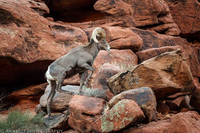
When I reached St. George I needed to get out of the Jeep and stretch my legs a bit. I drove over to Anasazi Ridge along the Santa Clara River and hiked to a few petroglyphs.

Two large rectangular-bodied bighorn sheep.


Two Big Sheep by IntrepidXJ, on Flickr

A very alien-like figure pecked into the top of a large boulder.


The Alien by IntrepidXJ, on Flickr

There were some real nice panels around this area.


Anasazi Ridge by IntrepidXJ, on Flickr

After a quick lunch back in St. George, I continued on to Mesquite where I topped off the fuel tank in my Jeep before heading south on the Gold Butte Road.

Low clouds hide the tops of the mountains in the distance as I made my way to Whitney Pocket.


Gold Butte Road by IntrepidXJ, on Flickr

I soon reached my first destination in Nevada- the trailhead to the Kohta Circus petroglyphs. After a nice hike across the desert I soon spotted the petroglyphs I was searching for.

I liked the ripples in the sand below the large panel of petroglyphs and made sure to include them in this shot.


Sand & Petroglyphs by IntrepidXJ, on Flickr

Here’s a wider view of the same panel.


Long Panel by IntrepidXJ, on Flickr

High above I spotted this pristine petroglyph panel and made sure to use my long lens for a closer look.


Kohta Circus Panel by IntrepidXJ, on Flickr

Hiking back across the desert to my Jeep I stopped for this photo as the clouds opened up and let a little light through in the distance.


Stormy Spotlight by IntrepidXJ, on Flickr

After returning to my Jeep I started the drive over to Little Finland, where I planned to photograph at sunset and spend the night.

On the way I stopped at this petroglyph panel above the wash.


Mud Wash Petroglyphs by IntrepidXJ, on Flickr

I reached Little Finland just as the late afternoon light was getting nice, so I grabbed my camera and started to explore the area.


Little Finland by IntrepidXJ, on Flickr


Through the Eye by IntrepidXJ, on Flickr


The Claw by IntrepidXJ, on Flickr


Standing Tall by IntrepidXJ, on Flickr


Opening by IntrepidXJ, on Flickr


Reach for the Sky by IntrepidXJ, on Flickr


Finland Creature by IntrepidXJ, on Flickr


Catching the Sun by IntrepidXJ, on Flickr

After the sun had set for the evening there was a nice glow on the sandstone that I stuck around for.


Stained Sunset by IntrepidXJ, on Flickr


Scream to the Sky by IntrepidXJ, on Flickr

When the light was gone for the day, I hiked back down to my Jeep and setup camp for the night. I read for a little while and then quickly fell asleep. It was a great first day to the trip.

>> Kohta Circus & Little Finland Photo Gallery


Jan 1 2013

Marty’s Moab Rock Art Tour

Moab Area Rock Art XXII
Saturday, December 1, 2012

The Original Trip Report on ADVENTR.CO

On Saturday I drove down to Moab to meet up with Marty again for some hiking and exploring. He’s going to be moving to Grand Junction at the beginning of the new year, so we wanted to get at least one more hike in before he got busy with the move. Over the last year Marty had come across some new rock art sites while out exploring the area, so today he was going to show me some of them.

I managed to time my drive to Moab so that I was near the Fisher Towers at sunrise.


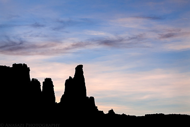
Fisher Silhouette by IntrepidXJ, on Flickr

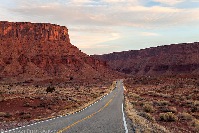
Highway 128 through the Richardson Amphitheater at sunrise.


128 by IntrepidXJ, on Flickr

I stopped along the Colorado River as the early morning light was striking the cliffs on the other side.


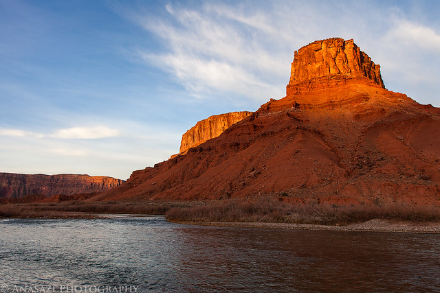
Colorado Morning by IntrepidXJ, on Flickr

I’ve driven the River Road to Moab many times over the years and have never seen a bighorn sheep along this stretch before. That would change this morning since this guy was standing on the shoulder of the road as I approached. I pulled over and changed my lens to get this shot before he climbed back up into the cliffs to join the rest of the group.


Climbing Ram by IntrepidXJ, on Flickr

On our first hike of the day we came across this boulder with a few petroglyphs on them. While these look pretty cool, there is something about them that just don’t add up to me. Not only did they look too ‘perfect,’ there were other figures pecked here that seemed to copy other figures found in the area, including a smaller but perfect replica of the ‘Moab Mastodon’ I’m far from an expert, but in my opinion these are not authentic. If anyone out there has seen these petroglyphs before and has an opinion, I’d love to hear it!


Elaborate Fakes by IntrepidXJ, on Flickr

Next we hiked to a small pictograph panel that Marty had found a few months back.


Paintings by IntrepidXJ, on Flickr

This figure was found nearby.


Alone & Faded by IntrepidXJ, on Flickr
Continue reading


Dec 26 2012

After Thanksgiving Swell Trip

San Rafael Swell Rock Art X
Black Friday & Saturday, November 23-24, 2012

The Original Trip Report on ADVENTR.CO

After spending most of Thanksgiving Day at home it was time to get back out exploring again. Normally I take at least a few trips throughout the year to the San Rafael Swell, but I guess I was too preoccupied with the Paria Plateau this year since I still hadn’t made it out there. I decided it was time to at least make one trip out to the Swell this year, so that’s where I headed. I left well before sunrise on on Black Friday and was still surprised to see so many cars park at the mall that early as I drove out of town. I still can’t imagine getting up that early to try and get a deal among a large crowd of people, I’d rather spend my morning catching a sunrise in the desert. I spent the daylight hours of Friday and Saturday exploring, hiking and photographing rock art sites. I revisited a few sites and searched for some new ones. I spent the night at a hotel in Green River so I didn’t have to drive all the way back home on Friday night. Though many of the sites I visited were in the San Rafael Swell, I also made a side trip or two into the Book Cliffs and other areas outside the Swell. Here’s a few photos from my two days of exploring…

One of the new sites I visited this trip was the petroglyph panel near Mussentuchit Flats. When I first arrived, most of the panel was in direct sunlight, except for this narrow section, which happened to be one of the more interesting parts. As soon as the sunlight struck this section, it was almost impossible to see these figures.


Mussentuchit by IntrepidXJ, on Flickr

The fading Butch ‘Casady’ inscription under a shallow overhang.


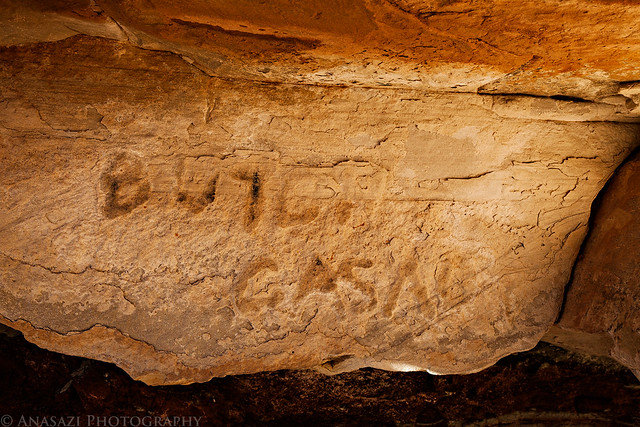
Butch Casady by IntrepidXJ, on Flickr

Cracked mud in the early morning light.


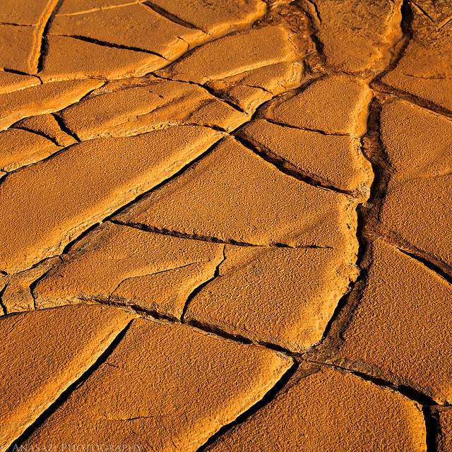
Cracks by IntrepidXJ, on Flickr

I’ve searched for this Barrier Canyon Style figure before without success, so I was happy to come across it this time.


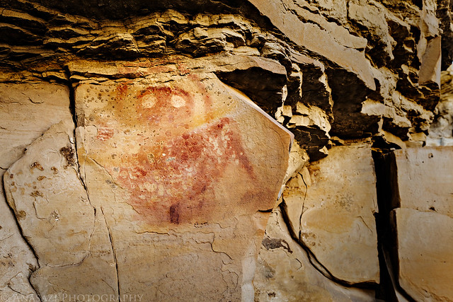
Top Half by IntrepidXJ, on Flickr

Faded red pictographs and handprints.


Three Hands by IntrepidXJ, on Flickr

Faded petroglyphs and red pictographs.


Faded by IntrepidXJ, on Flickr

A nice Barrier Canyon Style pictograph panel that I missed on a previous visit. Glad I was able to find it this time.


Inventory Panel by IntrepidXJ, on Flickr

Pictographs above water, an uncommon sight.


Reflection by IntrepidXJ, on Flickr

A beautiful Fremont panel in the warm afternoon light.


Rainbow Panel by IntrepidXJ, on Flickr
Continue reading