Jul
8
2009
 North Fork Cutoff (Silverton, CO)
The North Fork Cutoff trail is a quick and easy one. This trail follows the North Fork of the Animas River from the ghost town of Animas Forks to the start of the Engineer Pass trail. This route is mainly used as a quick connector to get from Animas Forks to Engineer Pass. This is also a good route if you would prefer to skip the rougher Mineral Creek trail but would like to get to the start of the Engineer Pass trail.
Even though this section of trail is just under 3 miles long, the scenery is great!
Please feel free to leave your comments and post your pictures from the North Fork Cutoff trail below.
GPS Tracks for the North Fork Cutoff
 North Fork Cutoff KML Track
 North Fork Cutoff GPX Track
(Right click and ‘Save Target As’)
This page last updated: 7/8/2009
Comments Off on North Fork Cutoff | posted in Trails
Jun
22
2009
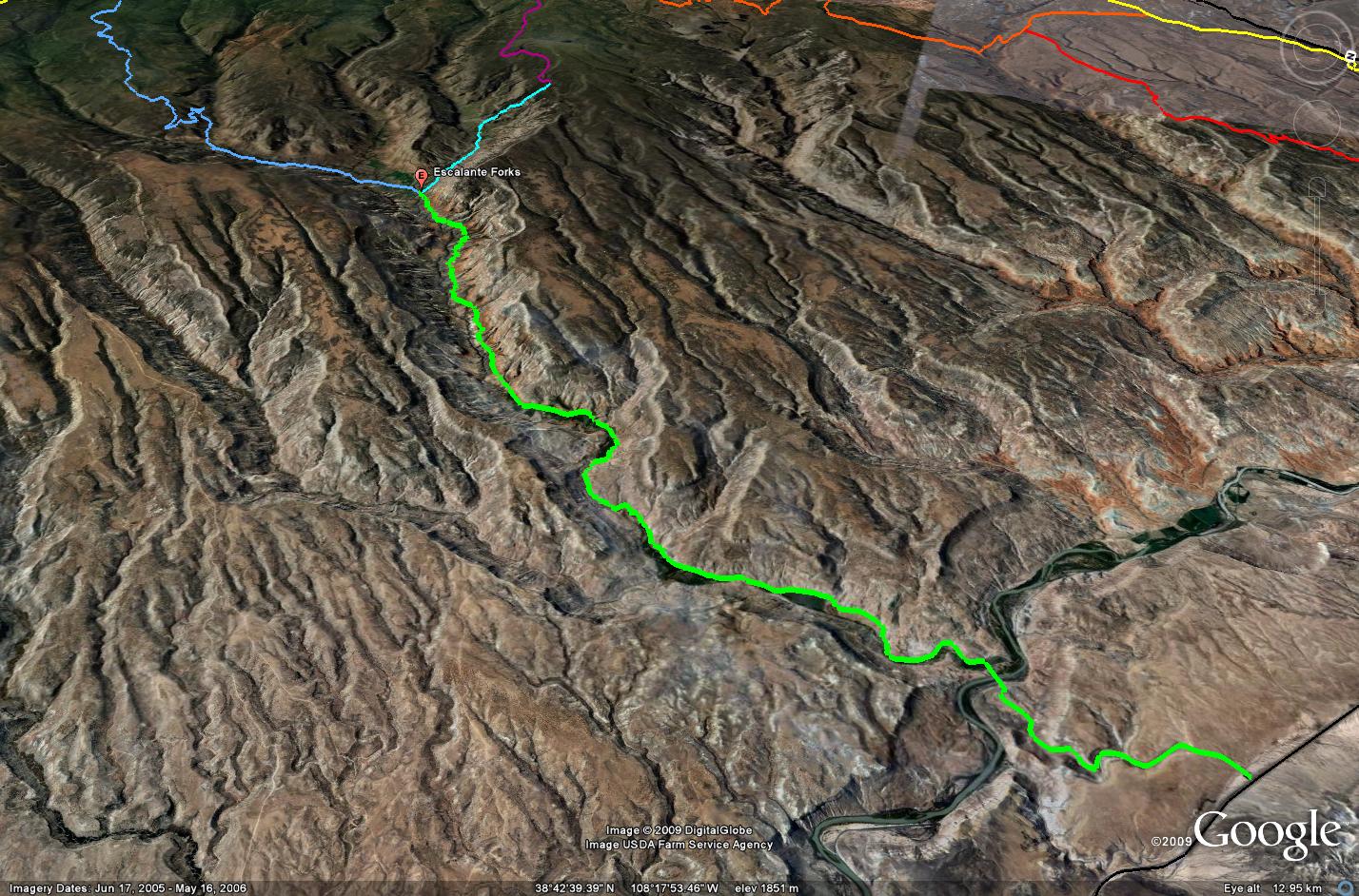
 Escalante Canyon (Delta, CO)
Escalante Canyon is a nice easy drive that takes off from US 50 just north of Delta, CO. The scope of this trail writeup starts at the highway and ends at Escalante Forks, where there is a Y-intersection to the Love Mesa and Palmer Gulch trails.
The entire length of this section of road is maintained and easily traveled by any vehicle. From the highway the road quickly drops down and crosses the Gunnison River. After crossing the bridge, the road crosses private property for a few miles before finally reaching public lands. There are a number of marked campsites along this section of the road.
While this trail offers no obstacles, the scenery in the canyon is great and there are a few old historical houses to check out. The first one is the Walker Cabin which was built in 1911 by Harry Walker. A little further up the road you will reach the cabin built by Captain Henry A. Smith against a large rock slab. Take your time to explore these structures.
Please feel free to leave your comments and post your pictures from Escalante Canyon below.
GPS Tracks for Escalante Canyon
Escalante Canyon KML Track
Escalante Canyon GPX Track
(Right click and ‘Save Target As’)
This page last updated: 6/19/2009
Comments Off on Escalante Canyon | posted in Trails
Jun
19
2009
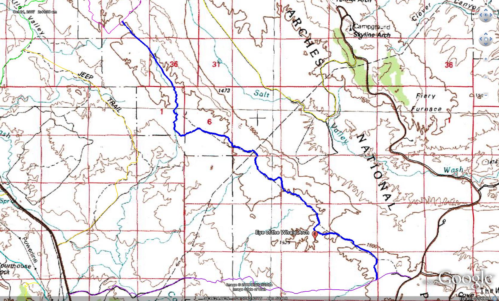
 Eye of the Whale (Moab, UT)
The Eye of the Whale Arch trail in Arches National Park is one of the few off-pavement routes located in the park. The trail travels between the Tower Arch trail and the Willow Springs Road. The park recommends you drive this route from north to south as there are a few steep sections with deep sand, but I feel most 4×4’s could drive this route in either direction. This trail has been closed in the past due to washouts, so you may want to check with Arches before planning your trip to make sure it is open.
The highlight of this trail is the Eye of the Whale Arch. While you can kind of see the arch from the trail, I recommend the short hike to get up close and personal with the arch. As I stated above, there are a number of sandy sections along this trail, and there is one steep slickrock ledge that needs to be driven. Other than that, most of the trail is pretty easy for a stock 4×4 and it follows the bottom of a wash for a ways. There are no spur trails or intersections along this trail, so route-finding is easy.
If you are looking for a way to checkout Arches National Park and avoid the crowds, combining Salt Valley Road, Tower Arch, Eye of the Whale and Willow Springs Road is a nice little loop that can help you do just that.
Please feel free to leave your comments and post your pictures from the Eye of the Whale trail below.
GPS Tracks for Eye of the Whale
Eye of the Whale KML Track
Eye of the Whale Track
(Right click and ‘Save Target As’)
This page last updated: 6/19/2009
Comments Off on Eye of the Whale | posted in Trails
Jun
19
2009
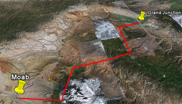
One of the most common questions that I am asked is to recommend a route off the pavement to get from Grand Junction to Moab. I have decided to put together this little post with information about all of the routes that I am familiar with.
Gateway-Castleton Road
This route is the quickest and easiest way to get to Moab from Grand Junction. About half the route is paved and the other half is off-pavement. The start of this route follows the Unaweep/Tabeguache Scenic and Historic Byway (Colorado 141) to Gateway and then follows the Gateway-Castleton Road the rest of the way.
Kokopelli 4×4 Trail
The Kokopelli Trail created by COPMOBA in 1989 has long been a popular route to mountain bike from Grand Junction to Moab. In the past few years, off-road enthusiasts looking for an alternate route to Moab have began following the Kokopelli Trail as well. I worked with a group from ExpeditionUtah to map out what we believe is the most accurate route that follows the bike trail as closely as possible.
Dolores Triangle Route
Another route that has recently gained a lot of interest is the Dolores Triangle Route. This route heads out of the Colorado National Monument and across the remote Dolores Triangle region. One issue with this route is that the Dolores River needs to be crossed to make it to Moab so it is only drivable by most vehicles in the late summer and the fall.
Sheep Creek Route
An alternate option to the Dolores Triangle Route above during the spring and early summer is the Sheep Creek Route. This one starts out the same way, but instead of heading towards the Dolores River crossing, it turns towards Gateway and descends the steep and narrow Sheep Creek switchbacks. It is possible that these switchbacks could be washed out and not drivable (they were repaired in early 2009) so make sure to do your research ahead of time. Once you reach Gateway, you will follow the Gateway-Castleton Road towards Moab.
If you have any comments, suggestions or questions please feel free to post them below.
This page last updated on: 12/19/09
Comments Off on Grand Junction to Moab Routes | posted in Trails
Jun
19
2009
Dolores Triangle 4×4 Route
Interest in the Dolores Triangle route from Grand Junction to Moab is becoming very popular with people wanting an alternate route to Moab instead of staying on I-70. Before planning to take this route to Moab, be sure to do your research on the Dolores River crossing. During the spring and early summer, chances are good that this crossing is not drivable. Your best bet to make it across the river crossing is the late summer and the fall. For real-time water data for the Dolores River near the crossing, check out this USGS website. If you would like to travel part of this route when the river is flowing too much to cross, you could also look into the Sheep Creek Route as another option.
This route starts out in the Colorado National Monument on Ds Road which you will follow to the Utah state line. From this point you will be following the maintained Dolores Triangle Road all the way to the Dolores River. There will be a couple of intersections in the road, but the main ones are marked and easy to follow. Just make sure to follow the markings to the Dolores River ford.
Once across the Dolores River you will meet up with the Entrada Bluffs Road. From this point you have a couple of options. If you want to head straight to Moab, take a right hand turn and make your way to Highway 128. The track provided below takes a left turn onto Entrada Bluffs Road and follows the Kokopelli Trail to the La Sal Loop Road. If you are planning to head this way, beware that you will need to descend Rose Garden Hill, which can be difficult for stock vehicles.
Once past Rose Garden Hill, you have one more choice. You can take a left onto Onion Creek and head back down to Highway 128, or you can turn left and continue following the Kokopelli through Thompson Canyon and on to the La Sal Loop Road.
The tracks below are a long version of the possible routes you can take once crossing the Dolores River. In the future I may be adding some alternate routes to help you plan, but in the mean time you can use my other trail specific pages for Onion Creek, Polar Mesa, Sand Flats Road and Thompson Canyon.
GPS Tracks for the Dolores Triangle Route
Google Earth Track (Version 1)
GPX Track (Version 1)
If you have any questions, suggestions or comments about the Dolores Triangle Route from Grand Junction to Moab, please feel free to post them below.
This page was last updated on: 12/19/2009
Comments Off on Dolores Triangle Route (Grand Junction to Moab) | posted in Trails