Jun
18
2009
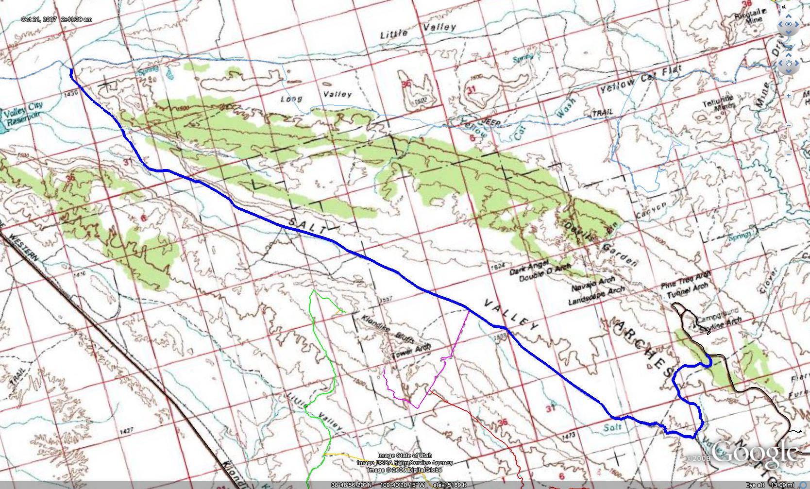
 Salt Valley Road (Moab, UT)
Salt Valley Road is an easy maintained road that can be travelled by just about any vehicle in good weather. This road can be used as another alternate entrance or exit to Arches National Park if you would like to stay off of the park’s main paved roads.
This road also gives you access to the Tower Arch and the Eye of the Whale Arch trails. The connecting trail from Klondike Bluffs also connects to the Salt Valley Road. There are a few campsites located just outside of Arches along this road as well.
Please feel free to leave your comments and post your pictures from Salt Valley Road below.
GPS Tracks for Salt Valley Road
 Salt Valley Road KML Track
 Salt Valley Road GPX Track
(Right click and ‘Save Target As’)
This page last updated: 6/19/2009
Comments Off on Salt Valley Road | posted in Trails
Jun
18
2009
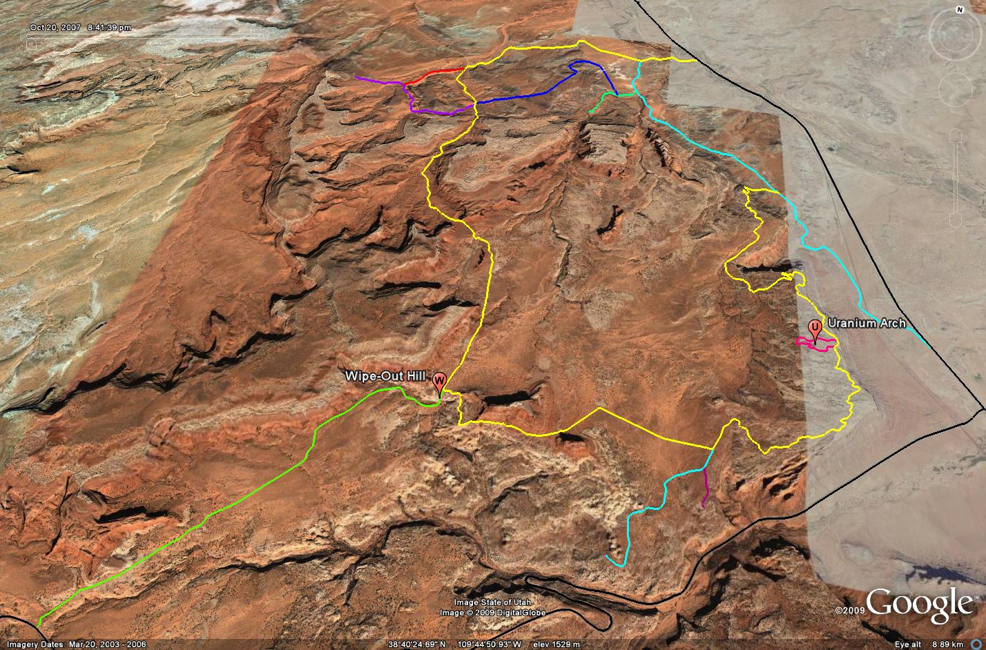
 Sevenmile Rim (Moab, UT)
Sevenmile Rim is an excellent trail with great scenery that starts out by following the rim of Sevenmile Canyon. The start of the trail off of Cotter Mine Road quickly ascends to the rim and offers great views down onto US 191 and across into the Arches National Park area, as well as into Sevenmile Canyon. There are a few short spur trails that lead to some overlooks as well.
After the tippy section, you have your choice, you can turn left and head down Wipeout Hill and then exit the trail to Highway 313, or you can turn right and follow the Sevenmile Rim trail past the Determination Towers and then into Tusher Canyon (You could also drop down Wipeout Hill and then climb back up to finish the trail if you want to hit that obstacle). Towards the end of the trail, there are a few optional trails you can follow that will take you to Tusher Tunnel and some dinosaur tracks in Mill Canyon. I have included all of these tracks in the GPS files below.
As if the views from the rim are not enough, the trail also travels between the Monitor and Merrimac Buttes and then past the Determination Towers. The scenery along the Sevenmile Rim trail is great, but this trail also offers some challenges to keep it fun. The start of the trail is rocky with a few smaller ledges. Once you travel away from the rim towards the Monitor and Merrimac buttes, the trail gets soft and sandy for a while. When driving between the buttes, you are back on an expanse of slickrock, that leads to one very tippy section. While this section of the trail looks intimidating, it is really not as back as it looks when you drive through it.
Please feel free to leave your comments and post your pictures from the Sevenmile Rim trail below.
GPS Tracks for Sevenmile Rim
Sevenmile Rim KML Track
Sevenmile Rim GPX Track
(Right click and ‘Save Target As’)
This page last updated: 6/18/2009
Comments Off on Sevenmile Rim | posted in Trails
Jun
18
2009
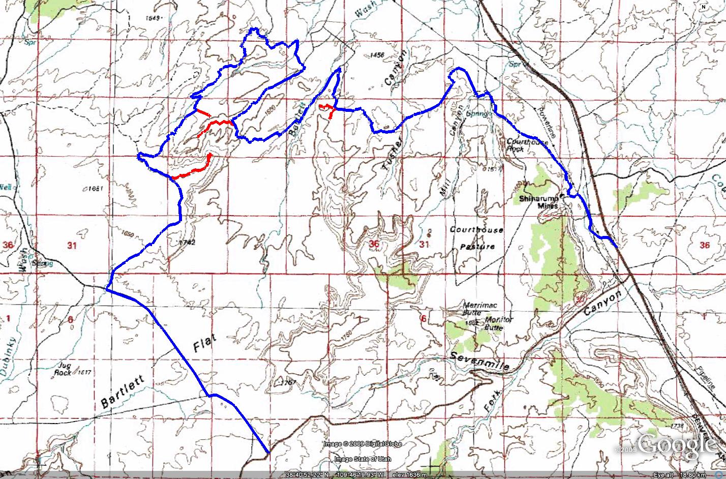
 3-D (Moab, UT)
The 3-D trail is easily one of my favorite trails near Moab. Much of the route is easy, but there are enough rough sections to keep it interesting. The trail was given the name 3-D because of the way it tours Hidden Canyon. First you drive through the canyon itself. Then you loop around to an overlook from the rim of Hidden Canyon. Finally you climb to an even higher overlook of the whole area, including Hidden Canyon.
The trail starts out on the Cotter Mine Road off of US 191 and makes it’s way past Tusher Tunnel to Bartlett Wash. From here you drop down into the spectacular Hidden Canyon and drive along a fun and sandy wash. After exiting Hidden Canyon, you will loop around through Lunar Canyon and some expanses of slickrock to the Hidden Canyon Overlook. You will pass an arch at ground level near the overlook, so keep on the lookout for that. Once you leave the overlook you will make your way over to Mean Hill. While this is not a difficult obstacle, it can be intimidating, as you are riding a narrow ‘hogback’ with dropoffs on each side of your vehicle. Soon you will reach Bartlett Overlook, which will offer outstanding views of Hidden Canyon and the area surrounding it.
I highly recommend anyone heading to Moab to check out this trail!
Please feel free to leave your comments and post your pictures from the 3-D trail below.
GPS Tracks for the 3-D trail
3-D KML Track
3-D GPX Track
(Right click and ‘Save Target As’)
This page last updated: 6/18/2009
1 comment | posted in Trails
Jun
17
2009
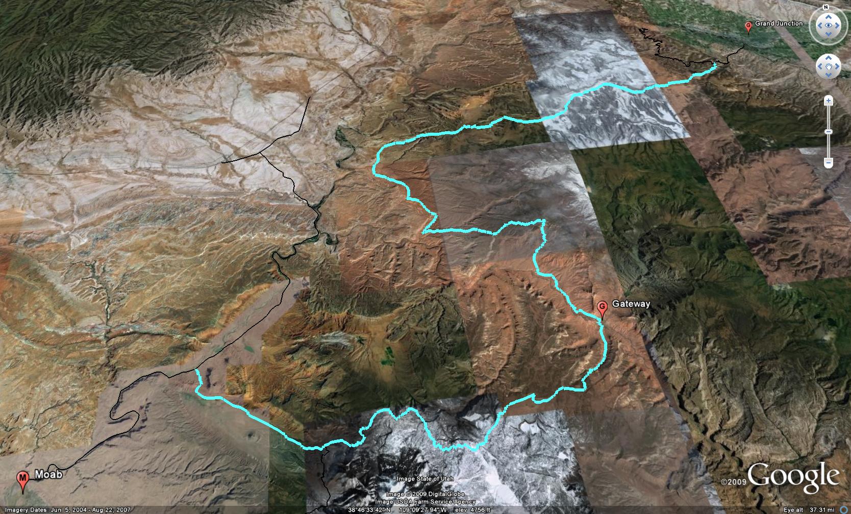
Sheep Creek 4×4 Route
There are a couple of possible routes to get from Grand Junction to Moab by staying off of the highway. I know a number of people are interested in taking Ds Road out of Grand Junction and across the Dolores Triangle to end up on Entrada Bluffs Road near the Dewey Bridge. While this is an excellent route between GJ and Moab, there is one huge problem with it; the crossing of the Dolores River is usually not crossable by most vehicles until later in the year. That means if you are heading to Moab in the spring or early summer, chances are that it is not a viable route for you.
There is another option that will take you across part of the Dolores Triangle, though. I call this the Sheep Creek Route. This route starts out the same way, by following Ds Road out of GJ and onto the Dolores Triangle. However, instead of taking the right turn towards the Dolores River ford, you will take the left fork and head towards Granite Creek. After dropping down to the Granite Creek crossing and then climbing back up the other side, this road will get narrow and rocky. It will be slower going from this point and hopefully you aren’t too concerned about your paint job, as the brush on this trail does get up close and personal to your vehicle.
After a right turn off of this trail comes the fun part. Descending the Sheep Creek switchbacks to Gateway. This section of trail is very steep and has a number of pretty tight switchbacks at the top. It is also prone to washing out, so you might want to check with the Grand Junction BLM office (970- 244-3000) before heading out this way. As a matter of fact, the switchbacks were just recently repaired by the BLM (May 2009) after having been washed out since the end of last summer (2008).
Once you reach the bottom of the Sheep Creek switchbacks, you will soon meet up and then parallel the Dolores River for a few miles to Gateway, CO. Back in Gateway you can stop and fuel up or grab a snack if needed. Cross the bridge over the Dolores and take a right into John Brown Canyon. From this point on, you can follow the Gateway-Castleton Road to the La Sal Loop Road, which will take you to Moab.
GPS Tracks for the Sheep Creek Route
Google Earth Track (Version 1)
GPX Track (Version 1)
If you have any questions, suggestions or comments about the Sheep Creek Route from Grand Junction to Moab, please feel free to post them below.
This page was last updated on: 12/19/2009
5 comments | posted in Trails
Jun
16
2009
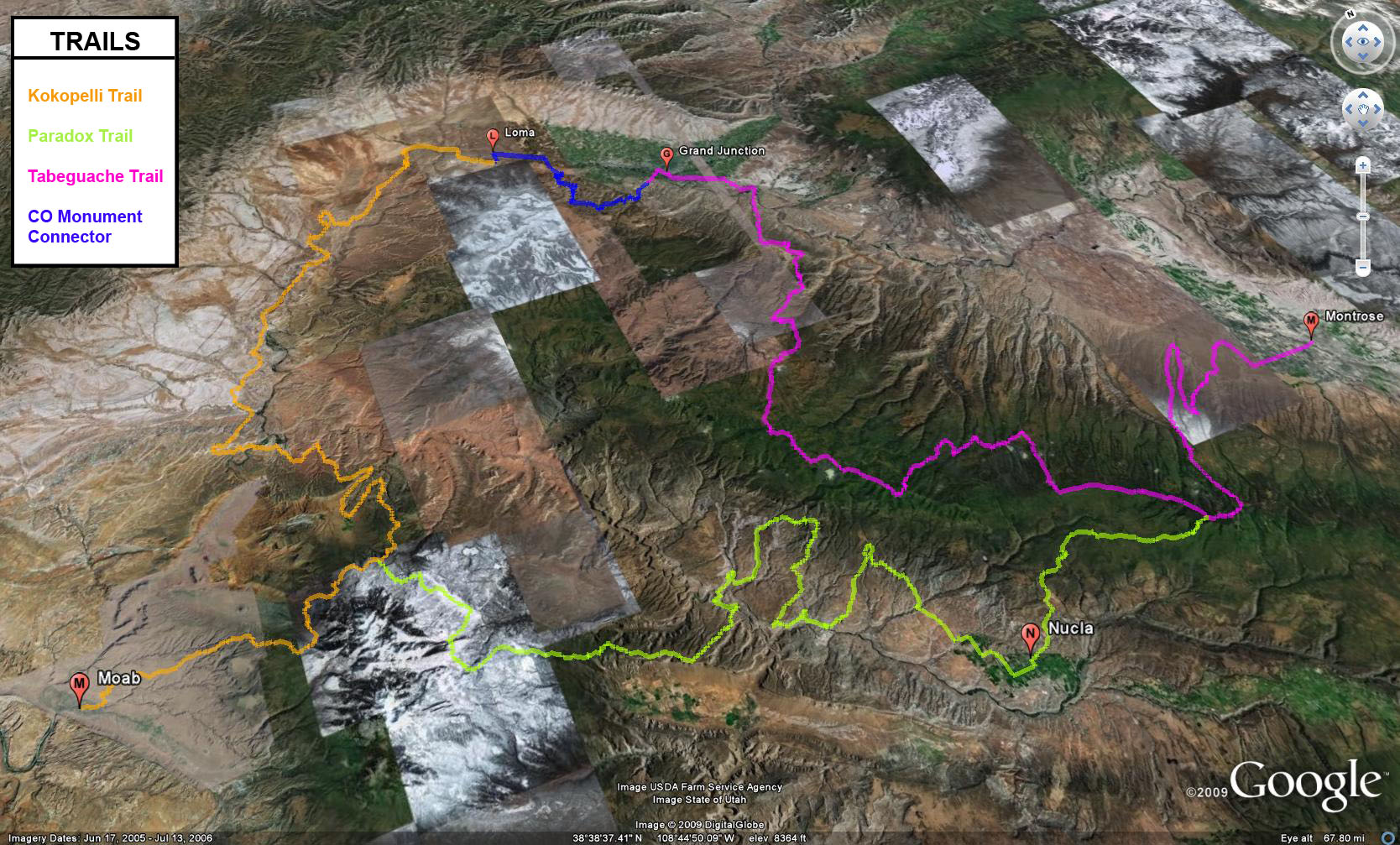
The Grand Loop 4×4 Trail
The Grand Loop 4×4 Trail is a 454 mile route that covers remote terrain in Western Colorado and Eastern Utah. This trail combines the Kokopelli, Tabeguache and Paradox 4×4 trails to form one large loop. While there are some short sections of driving on the pavement, much of this route is off of the pavement on backroads, and includes some rough trails, too.
This loop is usually started at the Kokopelli trailhead in Loma, CO and is driven in a counter-clockwise direction, but it can be driven in either direction. Not only is there the opportunity to get into the backcountry for a number of days, but there are enough towns around the loop that a stop for fuel or food is not too far out of your way. To enjoy each of the trails in the loop, I would suggest at least two days each, though each trail can be driven in one long day, if you push it. There are plenty of campsites located along each trail as they travel through mostly National Forest and BLM land.
For specific information about each trail in the Grand Loop, follow the links below for each section.
Just one note about this loop is that it is still a work in progress to perfect it. The route as it currenly is routed works great, however, I feel there are some sections that might be changed in the future to follow these trails as closely as possible. As I do more research and scouting of the trails, it is possible for these routes to change a little. So before you head out to check them out on your own, make sure to check each trail’s webpage for the latest updates.
Kokopelli 4×4 Trail Information (140 miles)
Loma to Moab
Paradox 4×4 Trail Information (127 miles)
Moab to Montrose
Tabeguche 4×4 Trail Information (154 miles)
Montrose to Grand Junction
Colorado National Monument Connector (33 miles)
Grand Junction to Loma
If you have any questions, suggestions or comments about The Grand Loop 4×4 Trail, please feel free to post them below.
This page was last updated on: 06/16/2009
Comments Off on The Official Grand Loop 4×4 Trail Guide | posted in Trails