Mar
8
2013
Death Valley Trip 2013 | Day 4
Tuesday, February 12, 2013
As usual, I was up and taking down my campsite while it was still dark out. Thanks to the long nights this time of the year I still managed to get plenty of sleep and was wide awake. I drove back to Badwater and hiked out to the salt polygons before dawn.
The 11,049 foot Telescope Peak and the rest of the Panamint Range stand tall over Badwater Basin (282 feet below sea level) at dawn.
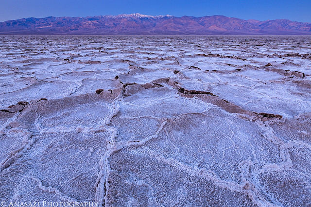
Telescope Peak Dawn by IntrepidXJ, on Flickr
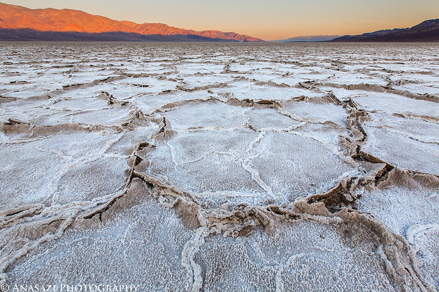
Sunlight strikes the Panamint Range across Death Valley.
Badwater Sunrise by IntrepidXJ, on Flickr
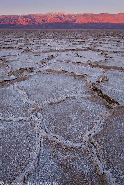
There were endless compositions with all the different, yet similar, shapes in the salt. This large polygon caught my eye as I hiked around the area.
Salt Polygons by IntrepidXJ, on Flickr
1 comment | posted in Adventures, Camping, Hiking, National Parks & Monuments, Photography, Trip Reports
Mar
7
2013
Death Valley Trip 2013 | Day 3
Monday, February 11, 2013
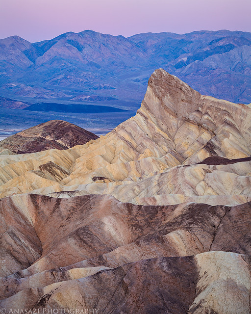
My alarm woke me up a few hours before sunrise on Monday morning. I quickly got my camp loaded back in the Jeep and started the short drive over to the popular Zabriskie Point. As usual, I was the first to arrive with plenty of time to scout the location in the dark. I guess I should mention that it was my birthday. I had purposely planned this trip to coincide with my birthday, and I couldn’t think of a better way to spend the day.
Looking over the badlands from Zabriskie Point shortly before the sun would rise for the day.
Zabriskie Badlands by IntrepidXJ, on Flickr
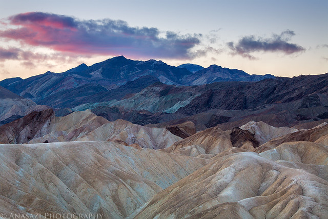
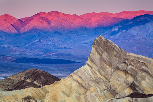
The prominent Manly Beacon, the Panamint Range and the Earth’s shadow come together for this scene.
Manly Dawn by IntrepidXJ, on Flickr
First light on the Panamint Range on the other side of Death Valley.
Zabriskie Point Morning by IntrepidXJ, on Flickr
Comments Off on Zabriskie Point to Badwater | posted in Adventures, Camping, Hiking, National Parks & Monuments, Photography, Rock Art, Trip Reports
Mar
6
2013
Death Valley Trip 2013 | Day 2
Sunday, February 10, 2013
After a good night of sleep my alarm woke me up before the sun was expected to rise. When I got out of my tent I noticed that some thin clouds had moved in overnight and the sky was completely overcast. I had originally planned to spend some time photographing Little Finland this morning, but with the overcast skies I decided to cancel those plans. Instead, I had a little breakfast, packed up my camp and started driving towards my next destination- the Falling Man petroglyph site.
On my way to the Falling Man site I drove right by Devil’s Throat, so I stopped for a quick look. It’s a giant sinkhole in the desert floor. This is not a good photo, but I’m posting it up anyway since I bothered to stop here.

Devil’s Throat by IntrepidXJ, on Flickr
When I made my plans to spend the first weekend of my trip in the Gold Butte region I really thought that the Kohta Circus petroglyphs were going to be the highlight of my visit. I was wrong. I had a lot more fun exploring the area around the Falling Man petroglyph. Not only were there petroglyphs to be found everywhere I looked, there was also colorful sandstone all over the place. It was like walking through a colorful maze searching for rock art around every corner! I spent more time in this area than I had anticipated and look forward to returning again in the future.
A photo of colorful sandstone in a small alcove reminiscent of scenes found at the Valley of Fire.

Color by IntrepidXJ, on Flickr
To access the rock art I had to first crawl through this passage in the rock. The petroglyphs lead the way.

Petroglyph Passage by IntrepidXJ, on Flickr
Comments Off on Falling Man to Dante’s View | posted in Adventures, Anasazi, Camping, Hiking, National Parks & Monuments, Photography, Rock Art, Trip Reports
Feb
14
2013
Sunday, January 27, 2013
By now I’m sure many of my regular readers are tired of seeing photos from the Colorado National Monument. For those of you who might feel that way, I’m sorry to say I have another trip report of photos taken there. Better stop reading now! After spending over five hours photographing the inversion layer in the Monument on Saturday I had no plans to return on Sunday. However, in the afternoon I noticed the clouds that had been hovering over the Grand Valley all day were finally beginning to break up. I couldn’t resist, so I grabbed my camera and drove back up there. I’m glad that I did!
As I was driving to the Fruita entrance I noticed the clouds hanging in the canyon obscuring the view of Independence Monument. I found somewhere to pull over and switched to my long lens for a closer look.
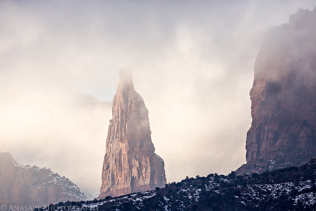
In the Clouds by IntrepidXJ, on Flickr
When I reached the Monument Canyon view I was pleasantly surprised to find many dynamic clouds in the canyon below.
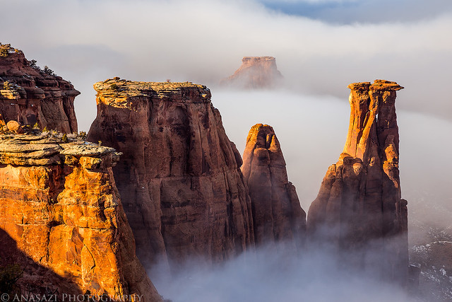
Clearing Storm by IntrepidXJ, on Flickr
A disappearing act.
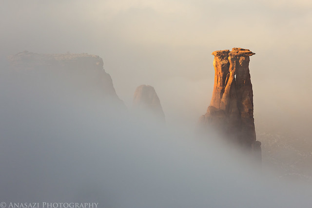
Kissing in the Fog by IntrepidXJ, on Flickr
Comments Off on Clearing Storm | posted in Adventures, Grand Valley, National Parks & Monuments, Photography, Trip Reports
Feb
11
2013
Saturday, January 26, 2013
On Saturday morning I slept in a little later than usual. A winter storm moved into the area overnight and when I looked outside towards the Colorado National Monument I could see that the humidity from the storm caused the inversion layer over the valley to thicken. I quickly got dressed and drove up to the Monument. I was planning on a short trip up there to hopefully get a couple of decent photos, but I ended up spending over 5 hours up there!
Since there was another layer of clouds above me there was no direct light the whole time I was up there, but I really enjoyed photographing the muted colors of the canyons in these conditions. It’s certainly different from what I normally shoot, which is what I was trying to do.
The base of Window Rock was just above the inversion layer.

Window by IntrepidXJ, on Flickr
The thick inversion filling up part of Wedding Canyon.
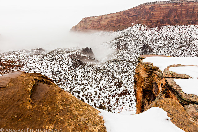
Filling by IntrepidXJ, on Flickr
The inversion layer sort of acted like water in the ocean. The fog would recede a little and then advance again. I waited until the wave of fog crashed against the cliff to take this photo.
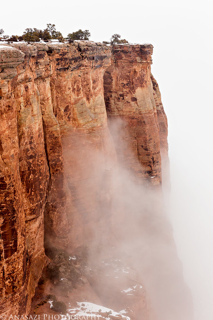
Wave by IntrepidXJ, on Flickr
Comments Off on Monument Inversion | posted in Adventures, Grand Valley, National Parks & Monuments, Photography, Trip Reports