Aug
15
2012
Saturday & Sunday, August 4-5, 2012
On Saturday I met up with Jackson and his family so that we could float a section of the Green River known as the Green River Daily. This section is a few miles long and located within Gray Canyon a few miles north of the town of Green River. There aren’t really any big rapids on this stretch of the river, especially at this year’s very low water flows, so we were just expecting a nice relaxing float with a lot of swimming to stay cool. I also hoped to find some new petroglyphs along the way.
After dropping off my Jeep at the Swaseys Rapid takeout, we continued in Jackson’s Prius to the put-in at Nefertiti. The last time I was on this road it had been freshly bladed and I don’t recall it being too rough, but unfortunately this time around it was a bit rocky and almost too much for the Prius. The most difficult part was through a few stretches of sand that he had to power through. Luckily, he somehow managed to get that little car to the end of the road without getting stuck or scraping up the bottom too badly. If he hadn’t, we would have been walking back to the Jeep and not getting on the river.
After reaching the put-in at Nefertiti, we got our boats setup under the shade of a large cottonwood tree.
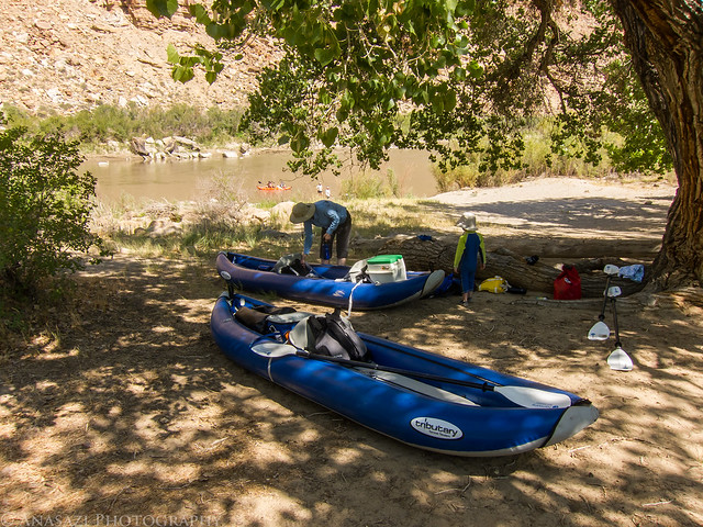
Getting Ready by IntrepidXJ, on Flickr
Ready to get on the river for the day.
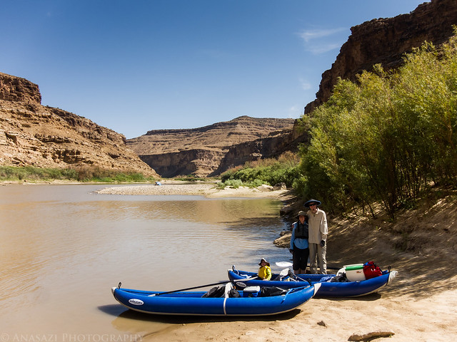
Ready to Launch by IntrepidXJ, on Flickr
Just around the first bend we paddled under the large Nefertiti Rock.
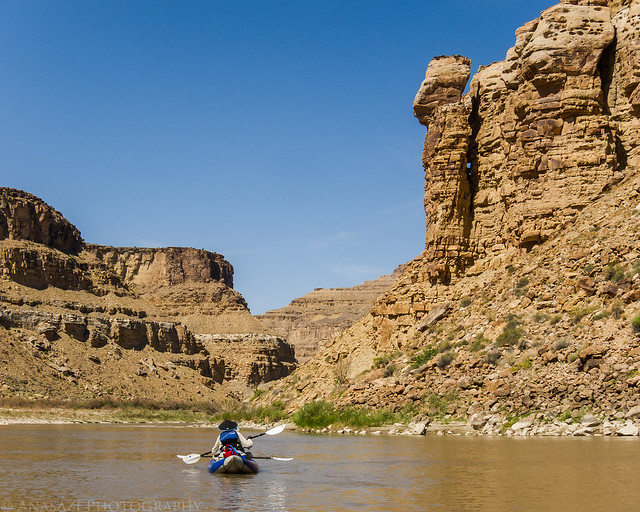
Below Nefertiti by IntrepidXJ, on Flickr
2 comments | posted in Adventures, Camping, Fremont, Hiking, National Parks & Monuments, Photography, Rafting, Rock Art, Trip Reports, Water Recreation
Jul
30
2012
Saturday, July 21, 2012
I left work at 11:00am on Friday, finished loading up the Jeep and made my way east on I-70 to the Front Range. One of my personal goals for the year was to hike to the top of three 14ers, so I decided to try and hike the Grays Peak and Torreys Peak combo to knock two more off of my list. I made it to the Stevens Gulch trailhead around 3:00pm and found a nice campsite nearby. Had I arrived later in the evening, I doubt I would have been able to find a nice campsite right near the trail. There were a few sprinkles of rain in the afternoon, but they only lasted for a short time. I spent much of the evening reading and relaxing. The sky stayed overcast until I went to bed around 9:00pm, so I didn’t even bother taking any photos around sunset.
My campsite with a nice view in Stevens Gulch. Grays Peak is visible in the distance.
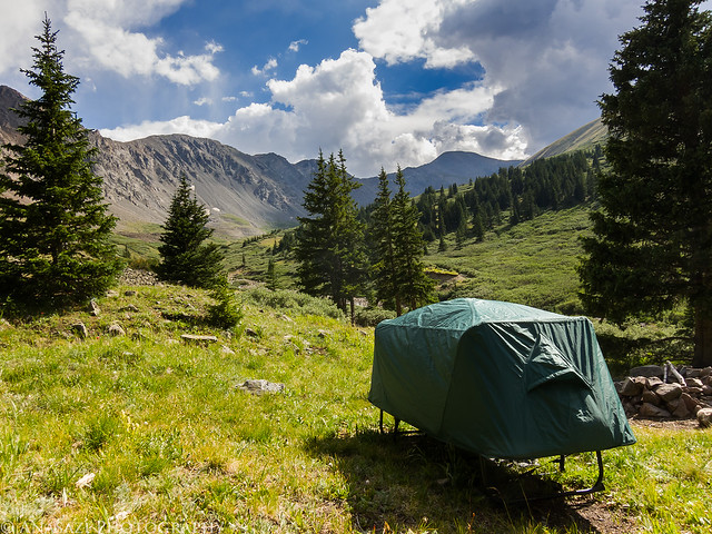
Stevens Gulch Camp by IntrepidXJ, on Flickr
My alarm woke me up bright and early at 4:00am on Saturday morning. After having a quick breakfast of oatmeal and getting my pack ready for the hike, I was on the trail at 4:30. I started the hike up Stevens Gulch under a canopy of stars with the silhouettes of the surrounding mountains just barely visible. There were a few other people on the trail at this time, but they were pretty far ahead of me, so I was by myself for a while. It was nice, especially since I knew the trail would be packed full of people in a few short hours. The stars soon faded as the dawn light arrived. As I was nearing the base of Grays and Torreys I was treated to the first light of the day striking both peaks as the sun was just rising in the east. I took a few photos of the peaks glowing orange before starting my climb up to the top of Grays Peak.
Just as the sun started to rise, it gave Torreys Peak a purplish glow for less than a minute. Luckily my camera was handy.
Early Torreys by IntrepidXJ, on Flickr
Then the mountains in front of me were bathed in amazing warm light. It was an incredible sight and made me wish I had dragged my heavy DSLR along with me. The mountain lit up in this photo is Torreys Peak.

Torreys Sunrise by IntrepidXJ, on Flickr
1 comment | posted in 14ers, Adventures, Camping, Hiking, Mountaineering, Summits, Trip Reports
Jul
26
2012
Saturday & Sunday, July 14-15, 2012
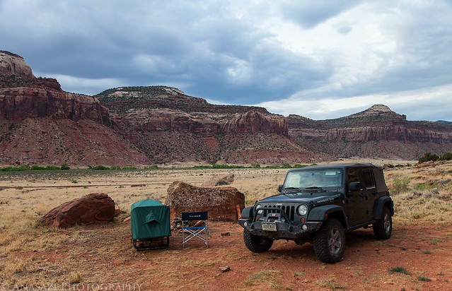
I first tried to explore Horse Canyon in the Needles District of Canyonlands National Park back in 2008 when I camped at Peekaboo with a few friends. Back then the entrance to the canyon had been washed out pretty good and there was a very deep hole blocking vehicle entry. For the past two years I have been checking the condition of the road so that I could finally get back there to start exploring the area, but both the Salt Creek and Horse Canyon roads have been washed out and closed for that long. I have hiked up Salt Creek Canyon twice during those two years, but Horse Canyon was a bit too long for a day hike. A few weeks ago I finally received word that the National Parks Service had finally reopened the roads in Salt Creek and Horse Canyon, so I quickly made plans to get back. I reserved a campsite at Peekaboo for the weekend and invited Jared and Marty to come along.
After work on Friday, I drove down to Cottonwood Canyon and setup camp so that I would be close to Canyonlands in the morning and wouldn’t have to do much driving. There were a few rain showers in the evening, but the precipitation stopped before I went to bed, and I had a great night of sleep.
Good Morning by IntrepidXJ, on Flickr
In the morning I had a little time to photograph this ruin high up on the canyon wall. I have driven by this site many times and had not been able to find it before. It would have been a long hike up to reach it, but unfortunately I didn’t have the time this morning to try. I will have to return again to climb up to the ruin for some closer photos.
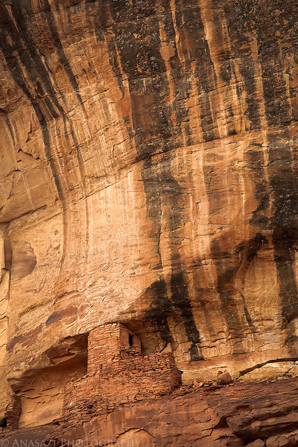
High Tower by IntrepidXJ, on Flickr
After photographing the tower, I continued my drive into the park where I met Jared and Marty at the Needle’s Visitor Center so that we could get our permits and the combination for the lock on the gate. Jared transferred his camping gear into my Jeep and parked his car at the trailhead before we continued through the locked gate into Salt Creek. The drive through the wash was in soft sand as usual, but the debris that had blocked the road in May had been removed. It was nice to be able to avoid this mosquito-infested area by closing the windows of the Jeep 😉 The deep holes that had blocked the entrance to Horse Canyon had also been filled in a bit. We drove through the holes and brush that was growing in the road and continued up Horse Canyon, where we would be spending much of the day searching for ruins and rock art.
We almost missed the remains of a tower near the mouth of the canyon. Good thing Marty spotted this one after we had passed it.
Watch Tower by IntrepidXJ, on Flickr
Comments Off on The Elusive Horse Canyon | posted in Adventures, Anasazi, Arches, Barrier Canyon Style, Camping, Hiking, National Parks & Monuments, Photography, Rock Art, Trip Reports
Jul
3
2012
Saturday, June 30, 2012
At 14,309 feet, Uncompahgre Peak is the highest point in the San Juan Mountains and the 6th highest in Colorado. It was also our destination this morning.
After work on Friday, Jackson and I loaded up my Jeep and headed south to the San Juan’s. We made a quick stop for dinner in Montrose and then we were soon passing through Ouray and turning off the highway on the rough road following the Uncompahgre River and Mineral Creek. Next we found ourselves driving at just under 13,000 feet as we crossed Engineer Pass and dropped back down along Henson Creek. When we reached the rough road that follows Nellie Creek we turned onto it and climbed a few thousand feet again until we had reached the boundary for the Uncompahgre Wilderness area and the trailhead to Uncompahgre Peak. We quickly setup camp in what was left of the twilight and got to bed early.
Bright and early on Saturday morning we were up and having a quick breakfast before starting the hike. As we entered the wilderness our surroundings were still in the shadows, but occasionally we would catch a glimpse of Uncompahgre Peak lit up with a golden early morning light. Next time I will have to get an earlier start so I can take a few photos of that (and also bring along my DSLR).
Uncompahgre Peak lit up with golden light on a cloudless morning.
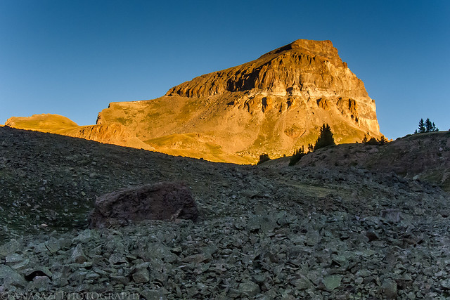
Uncompahgre Sunrise by IntrepidXJ, on Flickr
Uncompahgre Peak…that way!
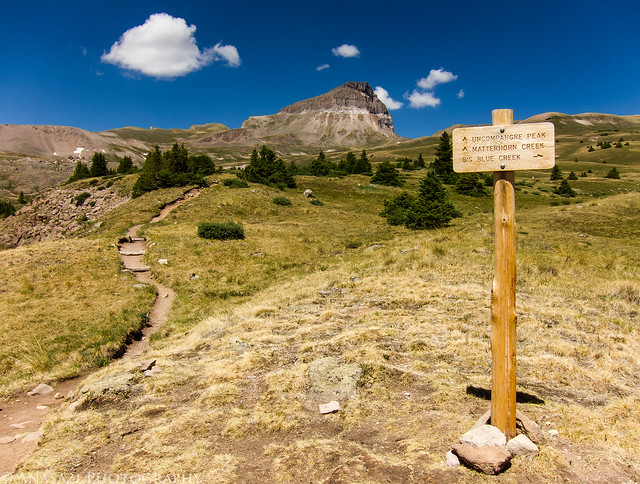
Intersection by IntrepidXJ, on Flickr
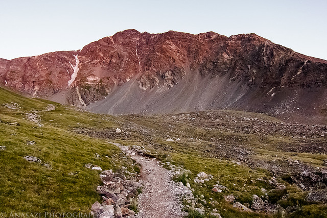
Easy trail through the alpine tundra.
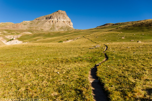
Path to Uncompahgre Peak by IntrepidXJ, on Flickr
Comments Off on Uncompahgre Peak | posted in 14ers, Adventures, Camping, Hiking, Mountaineering, Summits, Trip Reports
Jul
2
2012
Saturday & Sunday, June 23-24, 2012
After spending a few hours in the morning at the Shavano Valley Petroglyph Park near Montrose, we continued driving into the San Juan Mountains to get out of the heat for the weekend. Shortly after crossing over Red Mountain Pass we turned down the road along the South Fork of Mineral Creek and found a campsite for the weekend. After setting up our camp we drove through Silverton and made our way up Cunningham Gulch to the trailhead for the Highland Mary Lakes. As soon as we passed through Silverton the valley started filling up with smoke, and by the time we reached the Cunningham Trailhead the smoke had become pretty thick and there was even a little ash falling from the sky. We would later learn this smoke was from a wildfire that had started near Mancos.
A view of the smoke in Cunningham Gulch from the trailhead.
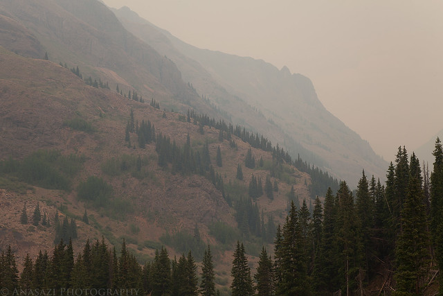
Smoke in the Gulch by IntrepidXJ, on Flickr
Entering the Weminuche Wilderness.
Weminuche Wilderness by IntrepidXJ, on Flickr
Smoke fills the sky with a view of the trail below through some pine trees.
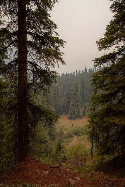
Trail Below, Smoke Above by IntrepidXJ, on Flickr
Comments Off on Beating the Heat in the San Juan Mountains | posted in Adventures, Camping, Hiking, Photography, Trip Reports