Dec
23
2011
November Cedar Mesa & Comb Ridge Trip 2011
Sunday, November 13, 2011
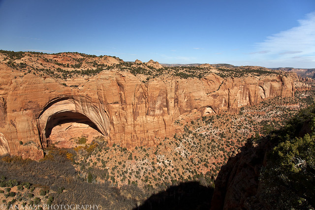
After spending an awesome weekend in Natural Bridges, Jackson and I spent a morning exploring Comb Ridge before heading back home. Monarchs Cave was one of the first ruins I ever visited on Comb Ridge and I was looking forward to revisiting them again on this trip, so that was our first stop.
An overview of the ruins in Monarchs Cave.

Monarch B&W by IntrepidXJ, on Flickr
They were built right up to the edge
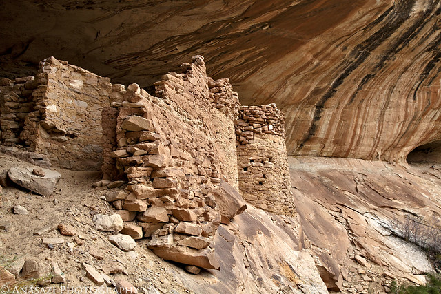
Monarch Fortress by IntrepidXJ, on Flickr
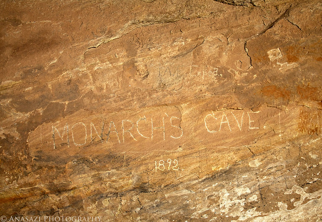
This Monarch’s Cave 1892 inscription was placed by the Illustrated America Exploring Expedition in 1892. Warren K. Moorehead was the leader of the Illustrated America Exploring Expedition which was sent to explore, survey, map, photograph and secure specimens from southeastern Utah. Although the IAEE collected few artifacts, the members of the expedition wrote enthusiastically and romantically about their adventures and discoveries in a series of articles for American Illustrated Magazine.
Monarchs Cave by IntrepidXJ, on Flickr
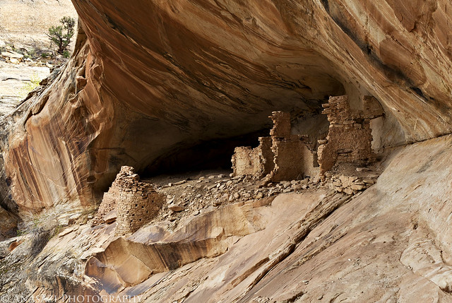
Monarch Cave Ruins by IntrepidXJ, on Flickr
Comments Off on A Morning on the Sandstone Spine | posted in Adventures, Anasazi, Hiking, Photography, Rock Art, Trip Reports
Dec
7
2011
November Cedar Mesa & Comb Ridge Trip 2011
Friday & Saturday, November 11-12, 2011
Right after an awesome three day weekend in Northern Arizona I was headed down to Cedar Mesa with my friend Jackson for another long weekend over Veterans Day weekend. Our destination and goal for this trip was to explore Natural Bridges National Monument for two days. I had been to the park once before, but at that time we only stayed up on the canyon rim and viewed the bridges from their respective overlooks. This trip we were planning on descending down into White Canyon so that we could begin to explore the area for the abundent ruins and rock art found within the park. This was just the first of many trips I plan to spend exploring the area!
One of the main pictographs I was looking for on this trip was the White Man. We managed to find that one first.

White Man Alcove by IntrepidXJ, on Flickr
There’s a few other interesting white pictographs next to it, including a large T-shaped design.
White Pictographs by IntrepidXJ, on Flickr
The White Man is larger than it might look in the photos above. Here’s Jackson standing next to it for scale.
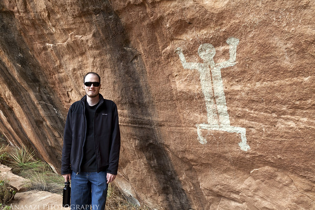
Jackson and the White Man by IntrepidXJ, on Flickr
Comments Off on Veterans Day Weekend at Natural Bridges | posted in Adventures, Anasazi, Hiking, History, National Parks & Monuments, Photography, Rock Art, Trip Reports
Dec
1
2011
Friday-Sunday, November 4-6, 2011
The Wave, located just south of the Utah-Arizona state line in the Vermilion Cliffs Wilderness Area, is one of those places that every photographer and hiker wants to visit. It’s hard to blame them because it is such a unique and amazing area. Unfortunately, because of it’s popularity, the BLM has a permit system in place that allows only twenty people per day the chance to experience this remarkable area. If you’ve read my blog for any length of time you might know that I am averse towards any kind of permit when I go out exploring, so in the past I have usually avoided those places. This year I have made an effort to finally visit some of those places that require a permit, including The Maze and the White Rim. A few months ago I decided that I would try to get a permit so that I could hopefully visit The Wave this year, too. Since there are only 20 permits per day, it can be difficult to obtain one. For anyone not familiar with the Coyote Buttes North permit system, ten of the permits for each day are awarded in a lottery three months in advance and the other ten are distributed in person the day before. I guess I was pretty lucky since I managed to snag two permits in advance on my first try. Once I had my permits, Amanda and I decided to make a long three day weekend out of the trip.
We left early on Friday morning and drove down through Monument Valley since Amanda hadn’t been through there before. Shortly after passing through Kayenta we turned off the main highway so we could make a quick visit to Navajo National Monument. We took the short Sandal Trail to on overlook of the Betatakin Ruins. The viewpoint was still pretty far away from the large alcove containing the ruins so I’m glad I had my long lens with me. We were lucky that most of the ruins were all in the sunlight, so I didn’t have to deal with a large shadow in part of the scene.
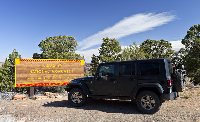
Navajo National Monument by IntrepidXJ, on Flickr
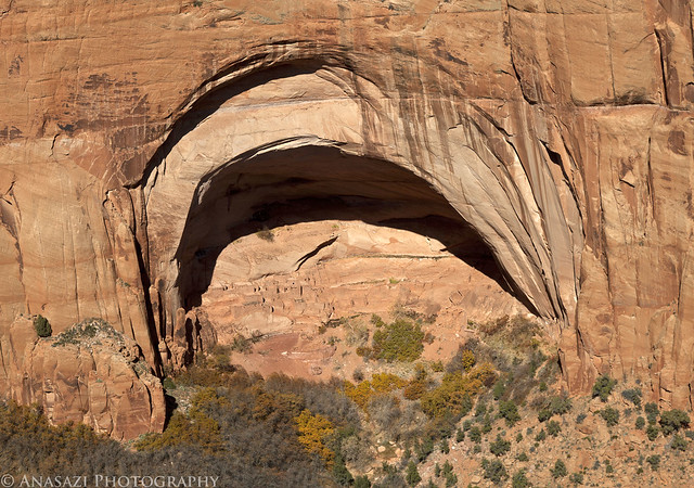
This huge alcove contains the Betatakin Ruins.
Betatakin Alcove by IntrepidXJ, on Flickr
A closer look at the ruins found here.
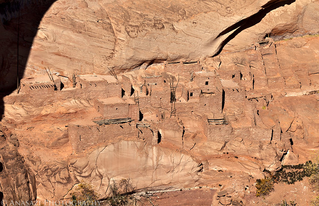
Betatakin Ruins by IntrepidXJ, on Flickr
Here’s a view of the large alcove in it’s canyon setting for a little better sense of scale.
Betatakin Overlook by IntrepidXJ, on Flickr
Comments Off on The Wave Weekend | posted in Adventures, Anasazi, Hiking, History, National Parks & Monuments, Photography, Rock Art, Trip Reports
Nov
6
2011
Arizona Strip & Southern Utah Wanderings | Day 8
Saturday, October 8, 2011
Our plan for Saturday was to drive from the Snake Gulch trailhead to Bluff, Utah. We would be going through Page, AZ and making a few stops along the way. When we arrived in Bluff our plans were to search for some new rock art and then to setup camp along Comb Ridge somewhere. In the end we didn’t stick to that final plan.
Our first stop was at a large alcove containing some rock art in Catstair Canyon. The lower portion of the panel has a few large petroglyphs and some red pictographs, but is pretty well vandalized.
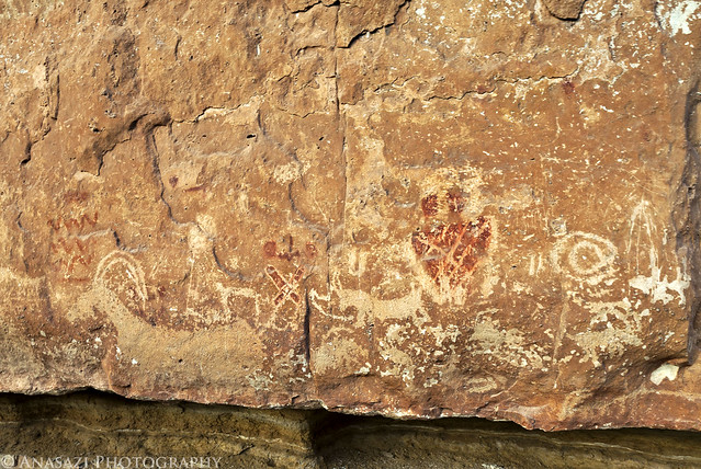
Lower Catstair Panel by IntrepidXJ, on Flickr
The higher panel is in a little better shape and has a red outlined anthropomorph and a zig-zag design. If you look closely, there are also some faint petroglyphs that are visible.
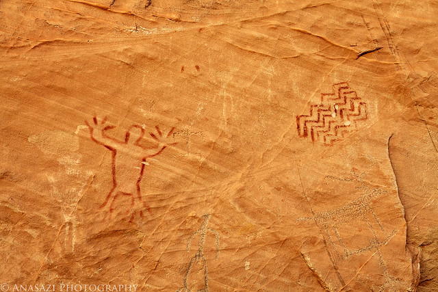
Catstair Pictographs by IntrepidXJ, on Flickr
A view in Catstair Canyon as it cuts through The Cockscomb.
Catstair Canyon by IntrepidXJ, on Flickr
Comments Off on Back Home Through Bluff | posted in Adventures, Anasazi, Hiking, Photography, Rock Art, Trip Reports
Nov
4
2011
Arizona Strip & Southern Utah Wanderings | Day 7
Friday, October 7, 2011
After a cold night of camping near the trailhead for Snake Gulch we woke up shortly after the sun began to rise. We had some breakfast and then set off into the canyon. Our hike turned out to be a long one at about 14.5 miles round trip, but it was mostly level without much elevation gain so it was pretty easy. Despite the cold night, the sun warmed things up nicely during the day for some very pleasant hiking weather. We ended up spending all day in the canyon between hiking, searching for rock art and taking a lot of photos! It was amazing just how many pictographs were in this canyon, and I’m sure we could have found many more if we had more time. Most of the pictographs in this canyon are attributed to the Basketmaker people from about 300 BC to 800 AD.
If you don’t like to look at a lot of photos of rock art, it’s probably best that you stop reading now 😉
Seeing our campsite in the light for the first time since we setup in the dark the night before. Yes, that is hail covering the picnic table and on the ground…it was a cold night!
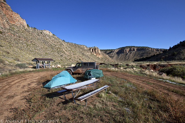
Trailhead Camp by IntrepidXJ, on Flickr
Shortly into Snake Gulch we entered the Kanab Creek Wilderness.
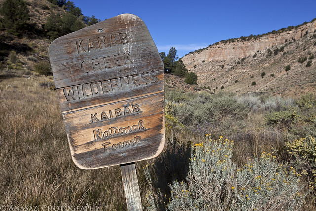
Kanab Creek Wilderness by IntrepidXJ, on Flickr
Typical scenery in Snake Gulch. A very nice canyon to hike through.
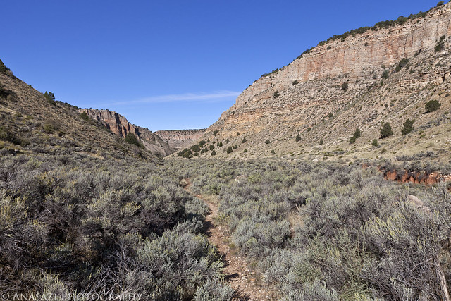
Snake Gulch by IntrepidXJ, on Flickr
Comments Off on Snake Gulch | posted in Adventures, Anasazi, Hiking, Photography, Rock Art, Trip Reports