Dec
2
2012
Saturday & Sunday, November 10-11, 2012
For a little over a year now I’ve been pretty obsessed with exploring and photographing the unusual and spectacular sandstone formations of The Paria Plateau. I’ve been to Coyote Buttes North five times, Coyote Buttes South two times, and the White Pocket three times and have come back with some nice images and had a lot of fun. There is just so much to see up there I could probably spend a lifetime exploring the area and not see it all. Unfortunately, I feel it’s time for me to take a little break from this area so I can concentrate on exploring some other areas on the Colorado Plateau for a while. This will probably be my last trip report from The Paria Plateau for a little while. Don’t get me wrong, I might head back down there once or twice next year, but I certainly won’t be driving down six or seven times like I’ve done this past year.
After work on Friday, Amanda and I started our drive south down to Page once again. There were some pretty good storms moving through the area which slowed us down a little and gave us some very strong winds to drive through. We eventually made it to our hotel, just a little later than I had anticipated. We quickly got to bed so I could be up bright and early for the sunrise on Saturday morning.
Since I had no plans to get up super early and hike into Coyote Buttes North before sunrise, I decided to head over to Horseshoe Bend for the sunrise while Amanda slept in a little later at the hotel. I had the place to myself for the sunrise which was a pleasant experience. About 20 minutes before the actual sunrise there was a nice glow that lit up the sandstone.
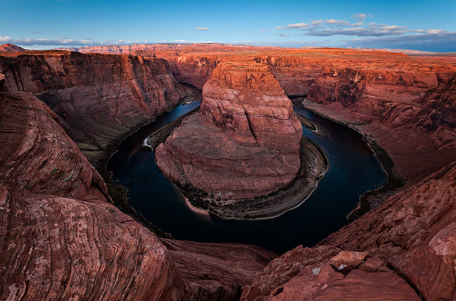
Horseshoe Bend Dawn by IntrepidXJ, on Flickr
My shadow on the golden sandstone as the sun rises behind me.
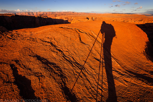
Long Shadow by IntrepidXJ, on Flickr
I just love warm morning light on sandstone, which there is no shortage of here.
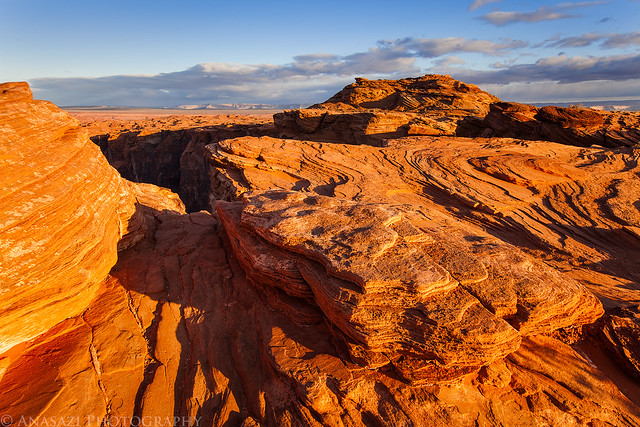
Sandstone Sunrise by IntrepidXJ, on Flickr
Comments Off on The Paria Plateau | posted in Adventures, Anasazi, Arches, Hiking, National Parks & Monuments, Photography, Rock Art, Trip Reports
Nov
26
2012
Thursday – Sunday, November 1-4, 2012
After work on Thursday evening I got in my Jeep and drove into Utah again. I had taken Friday off from work and was planning on meeting a group of friends in Beef Basin for a long weekend of camping and exploring the area. A few months earlier my friend Rob had tipped me off about a large petroglyph panel in the area he knew I would be interested in finding, and that was the beginning of planning for this trip. I arrived at our predetermined campsite in the dark and found Marty already there with his tent setup and a campfire already going. I was surprised to only be the second person there but knew the others would arrive shortly. Twenty minutes later Alex, Rob and his companions showed up. We sat around the fire for a little while waiting for the others, but headed to bed before anyone else arrived since we planned an early start for the following day. As soon as we were in our sleeping bags Jared and his brother Brian showed up. Later that night I heard Dave and his son pull up in their Jeep. We had all made it.
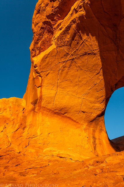
Friday morning I was up early and it looked like there might be a good sunrise, so I got in my Jeep to find a place to take some photos and ended up at a nearby ruin. I was hoping the sky would light up with color, but only the horizon turned a little pink.
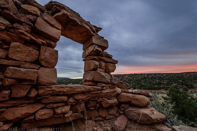
Open Window by IntrepidXJ, on Flickr
After returning to camp and waiting for everyone else to finish getting ready we got in our vehicles and drove over to the Fable Valley Trailhead. We were planning on exploring Gypsum Canyon following a route that Rob had planned out.
We started out hiking along an old closed road that followed the rim of the canyon. This is looking back at the confluence of the two upper forks of Gypsum Canyon.
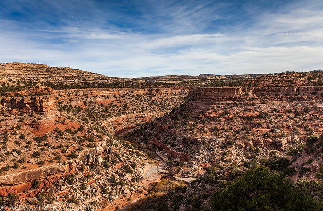
Gypsum Fork by IntrepidXJ, on Flickr
Once the old road ended we were left scrambling and route-finding our way along the rim of the canyon and then across a small side canyon.
Looking down the canyon towards the confluence with Fable Valley from the rock we stopped at for a lunch break.
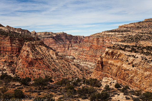
Down Canyon by IntrepidXJ, on Flickr
1 comment | posted in Adventures, Anasazi, Camping, Canyoneering, Hiking, Photography, Rock Art, Trip Reports
Nov
18
2012
Sunday, October 28, 2012
It was one of those days that I just needed to get out hiking and exploring by myself, so that’s what I set out to do. Last year around Christmas I had planned to hike along the Dolores River near Bedrock but got a severe headache on the drive there and had to turn around and head back home. I hadn’t made it back that way yet, so I thought it would be a good time to try again. After leaving home and driving through Unaweep Canyon to Gateway, I then followed the Dolores River to Paradox Valley and turned off at the dead-end road by the Bedrock store to the boat ramp. One day soon I want to float the Dolores River from the Big Gypsum Valley to Bedrock and wanted to check out the takeout. After leaving the boat ramp the road I was on got a bit rougher, but I managed to drive a little ways further until I reached and area that was completely washed out. I parked my Jeep there and continued along the river on foot. The hike was easy and for the most part since it followed an old road that hadn’t been drivable in quite some time. After a few miles I reached a few boulders with petroglyphs on them that I had hoped to find.
On the back of the main boulder there were a few faint bear paw petroglyphs next to some nice lichen.
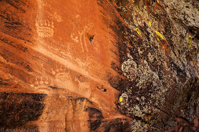
Bear Paws by IntrepidXJ, on Flickr
The front of the main boulder had a bunch of faded petroglyphs that have been vandalized over the years.
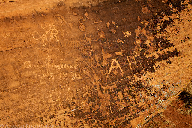
Petroglyphs & Graffiti by IntrepidXJ, on Flickr
Triangle body with big hands.
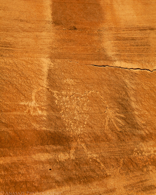
Long Arms by IntrepidXJ, on Flickr
Two more paw prints.
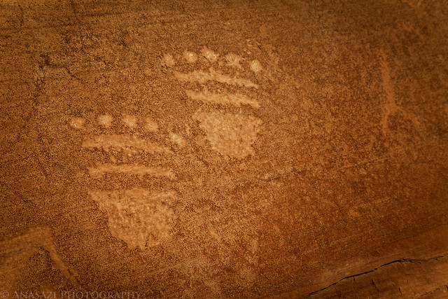
Prints by IntrepidXJ, on Flickr
Comments Off on Along the Dolores | posted in Adventures, Anasazi, Dinosaur Tracks, Hiking, Photography, Rock Art, Trip Reports, Ute
Nov
12
2012
Moab Area Rock Art XXI
Saturday, October 20, 2012
This weekend, even right after my week-long trip, I was ready to get out hiking and exploring again. I figured that since I hadn’t been down to Moab for a while it might be a good time to get back for a day trip. Last year I spent some time exploring Mill Creek Canyon and wanted to get back to continue my search for rock art.
Before driving into Moab, I stopped at La Boca Arch to catch the sunrise. Here’s the arch in the soft dawn light before the sun came up.
La Boca Arch Dawn by IntrepidXJ, on Flickr
Early morning light striking the arch.
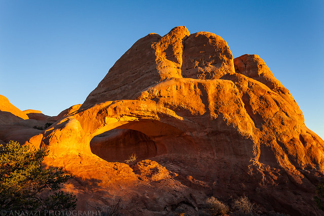
La Boca Arch by IntrepidXJ, on Flickr
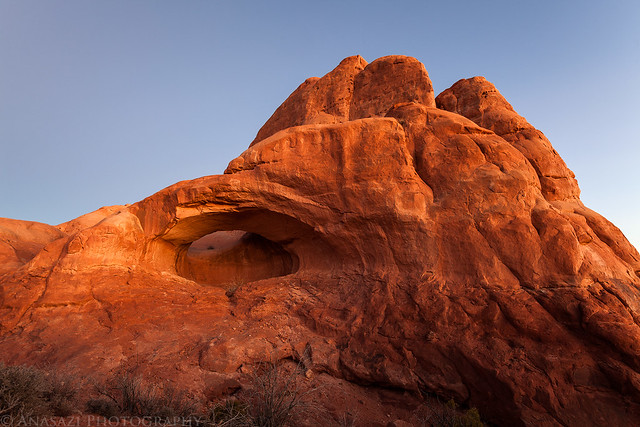
A closer look at the underside of La Boca Arch.
Under the Arch by IntrepidXJ, on Flickr
Comments Off on Rock Art & Fall Colors | posted in Adventures, Anasazi, Arches, Hiking, Photography, Rock Art, Trip Reports
Nov
6
2012
Arizona Strip & Southern Utah Wanderings | Day 8
Saturday, October 13, 2012
It rained again on Friday night. Not near as much as the previous night, but enough to make everything wet when we took down camp in the morning. Once we got our camp packed up into the Jeep and had a little breakfast, we drove over to the Bullet Canyon trailhead so we could start our hike for the day. Our main destinations for today would be Perfect Kiva and Jailhouse Ruin, but we would explore the canyon along the way, too.
About seven miles to Grand Gulch from here, but we weren’t planning on going that far this time. I’m definitely going to have to check out the full canyon on a future backpacking trip.
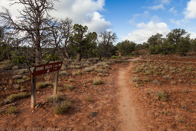
To Grand Gulch by IntrepidXJ, on Flickr
Shortly after descending into Bullet Canyon from the rim, Jared spotted these pictographs.
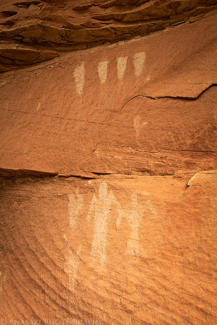
White Pictographs by IntrepidXJ, on Flickr
We also passed the remains of a tower up on the rim of the canyon.
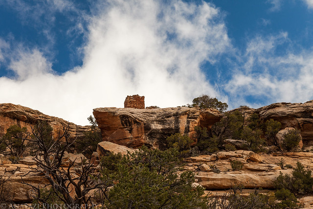
Rim Tower by IntrepidXJ, on Flickr
Comments Off on Bullet Canyon | posted in Adventures, Anasazi, Camping, Hiking, Photography, Rock Art, Trip Reports